 Route Editor

| Guide | ♦ | 6 Triplogs | 0 Topics |
details | drive | permit | forecast | 🔥 route |
stats |
photos | triplogs | topics | location |
| 18 | 6 | 0 |
Canyons are inherently risky. Flash floods occur without notice on sunny days. Technical skills & surrounding topography knowledge required yet does not eliminate risk.
Gotta love a hike that requires a wetsuit by andrewp   Warning WarningThis route involves off-trail hiking, boulder hopping, swimming, and other activities which are inherently risky. Be sure to carefully evaluate your skills and comfort before attempting. Although this is a reasonably easy route compared to other canyoneering activities, it still presents some challenges in which a bad decision could have a very lasting impact on your life (no pun intended). Know your limits!!
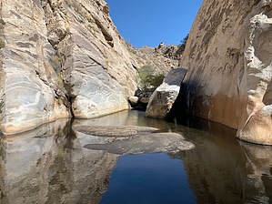
The concept here is simple: 1) Hike into Sabino Basin 2) Find the stream (east or west fork) 3) Follow the water out In practice, it's a lot of fun! Prologue You'll need somewhat different preparation for this one as the water presents its own challenges. Not only is the slip-and-fall risk greater, but you'll be in and out of the water to the point that you need to prepare for potential exposure-related issues. Things you need: • Waterproof pack: You'll need some sort of waterproof pack or keg to keep your stuff dry. Assume that this item will get submerged, so choose appropriately. There are a few 30L drybag backpacks on Amazon for less than $30, and they appear to work great. • Wetsuit: Needed for all but the warmest months (at least through April). A 3/2 full suit is a good option. • Towel: Compact microfiber towel, not a beach towel • Footwear: This one is a personal choice, but you need something which has good wet traction, sheds water easily, and provides good support. Think trail runner, not surf bootie. If you're prone to getting cold feet, then you might want some neoprene socks as well. • Common sense: This is a pretty straightforward route, but there are a few spots where you could get into really big trouble. Make every step a thoughtful one! Things you might want to bring along: • PLB: There's no cell service in the canyon, and although you're close to the trail at all times, you won't be visible from the trail. If you get into trouble, an SOS button may be your savior. • Helmet: There are some spots where you may easily lose your footing and introduce your head to something hard and immovable. • A Buddy: This route is a lot of fun and even better with a friend or two. There's also safety in numbers in case something bad happens. • Rope: Lightweight rope (like paracord) to lower your pack or otherwise tether it while you work through an obstacle. If you're an experienced climber, you might want to bring more gear for a short rappel, but this shouldn't be needed. Hike Either walk the tram road or take the tram to the last stop. Hop on Sabino Canyon Trail #23 all the way to the junction with the east and west fork trails. Hang a left onto the West Fork Trail #24 and jump into the stream at the first crossing (this is the east fork). Change into your wetsuit when appropriate, and follow the water out. It's just that simple. Alternatively, you can continue on the west fork trail to several different points to enter the west fork stream bed. This will be similar terrain to the east fork, but somewhat longer. Once suited up, you're ready to get wet. As you progress, you'll encounter some larger pools before the east and west forks converge. These are a blast to blow through and relatively sane in terms of exposure. After the confluence of the east and west forks, the canyon opens up a bit, and the stream becomes slower and less wild. For the most part, the water is shallow, and the terrain is marshy. As you continue, the canyon narrows and becomes more technical. At the narrowest point, you encounter Miner's Pool which is deep on the approach side and a fun spot to spend some time. Downstream from here, you'll encounter the most technical terrain, and you'll need to be paying attention. It is possible to traverse these more technical sections without too much trouble, but it will require careful observation and thought. Please pay attention to the depth of the pools below, as many of them aren't deep enough to allow for a jump from above without some serious injury potential. Once you're through the technical section, the canyon opens up again, and the stream slows down. Soon you'll encounter the trail that leads back up to the end of the tram road. You can exit here or continue down to the next road crossing near tram stop 8. Check out the Official Route and Triplogs. Leave No Trace and +Add a Triplog after your canyon trip to support this local community. | |||||||||||||||||||||||||||||||||||||||||||||||||||||||||||||||||||||||||||||||||||||||||||||||||||||||


