Route Editor

| Guide | ♦ | 21 Triplogs | 1 Topic |
details | drive | permit | forecast | 🔥 route |
stats |
photos | triplogs | topic | location |
| 143 | 21 | 1 |
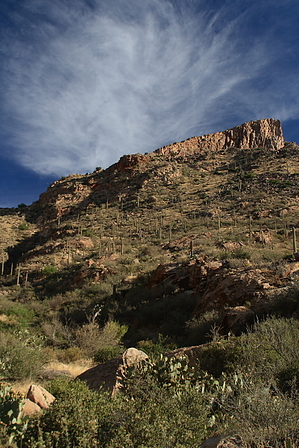
Come Bleed on the Cleaver! by fricknaley  Warning WarningThis is an extreme Pusch Ridge bushwhack: Exposure, bad footing, and blood-letting catclaw are a guarantee. Why even do it? Serious Catalina and Pusch Ridge hikers have to, I guess. Background Peak 4910 is known locally as The Cleaver. It's a lop-sided pyramid that sits in the saddle between Pusch Peak to the west and Bighorn to the east. Its west bank is fairly graded, and its northeast face is vertical. From most of Tucson, you cannot even see it. Certain vantages in the city allow a brief glimpse. The best view is from the Pima Canyon trail in western Pusch Ridge. The Cleaver is a beautiful, hidden (guarded even) peak of mystery. Can you get there? Is it worth trying? Hike the canyon enough, and these sinister thoughts will slowly warp your sense of reason... I've got to climb the Cleaver.
Route The best way to the Cleaver (if there is one) is to take off from the popular Pima Canyon trailhead and head into the canyon. Pima Canyon is one of the most popular trails in Tucson. If you live here, you've been here. The early reaches of Pima are easy. The trail passes through some private property as it crosses the desert and slowly climbs towards the canyon. The views of Pusch Ridge here are always great, especially the south bank of Pusch Peak. This is easy, smooth sailing. As you get to the canyon proper, the walls narrow in and quickly tower over you. The wash is initially on your right, and you'll cross over it right when you get to the canyon. Don't be surprised to see a little water in the wash, Pima holds it well. As you enter the canyon, you also get your first look at Table Mountain high up to your left with its distinctive diamond-shaped southern face, another Pusch Ridge monster for another day. Just follow Pima Canyon for a touch over 1.5 miles, you'll cross the wash a couple more times. Ultimately it will be on your left. What you are looking for is a spot along the trail where you'll notice things become considerably lusher. And Cottonwoods, big huge cottonwoods on the right. Again, if you've been here, you know the spot. This is about 1.55-1.6 miles from the trailhead. Just before you get here, look up and left. There's the Cleaver just peaking around the corner at you. Don't go much farther. If you've got a great look at the Cleaver in its entirety, you have gone too far. At this little shaded paradise, you will have to break left off the trail and go west. It's gonna be ugly, and it's gonna get worse. You need to follow the drainage coming down from the west end of the Cleaver. There is a saddle at the base of the broad west slope. The drainage comes down from here. This is your target. There is no trail, no route, and nowhere else to really go. As best you can, I would recommend following the drainage and breaking out when you just can't break through the growth. The growth... wow, is the drainage overgrown. Catclaw. Shindaggers. More catclaw. The higher up the drainage you get, the steeper and narrower it gets. Breaking out to avoid getting shredded becomes harder. I mostly broke out right when I could. The footing isn't too bad until you get almost to the top. Once you get near the top of the drainage, I recommend breaking out the LEFT side now. The right wall becomes vertical. The drainage is so overgrown you couldn't possibly move in it. If you break left near the top, you can ride the grassy and shindaggery ridge up the final push to the saddle. The footing is dicey here. Even some of the larger boulders are unstable. The saddle is about 1 mile from where you left the trail and about 1200 feet above. There is a cairn. To your left is Pusch Peak. To your right, peaking around the Cleaver, is Bighorn. The view down the drainage you climbed to Pima Canyon and Rosewood Point is gorgeous and scary. Can you make it down? Yes. Now immediately to your right is a wall that leads to the western slope of the Cleaver. This is the only place where you need to truly climb with your hands. There are 2 short 5-8 foot sections you must climb up immediately. They are not bad, just a little scary because you feel a little exposed (and wobbly after the drainage). Just be careful. The way up these two short sections is obvious. Once this is done, the rest is just grinding up boulders and shindagger infested grasslands. It's not even 1/4 mile to the summit, but it feels like it. I would recommend staying just a touch right as you go up. Straying too far left will put you at a several hundred-foot vertical drop (it's called the Cleaver for a reason) and is a little too tough of boulder hopping. You can occasionally see the summit as you work your way up. And then you're there. From the top, you just stare at Pusch Peak and Bighorn in amazement. The view up and down Pima Canyon is phenomenal. This peak sees very few visitors. Feel proud. You climbed the Cleaver. Head back the way you came as best you can. As always on this trail, your route is more or less determined by which way hurts the least because they all hurt. Wear pants, consider long sleeves and gloves. Hiking poles come in very handy to help ward off the horrendous catclaw. Map/GPS required too. Please be careful.
Check out the Official Route and Triplogs. Note This is a more difficult hike. It would be unwise to attempt this without prior experience hiking. Leave No Trace and +Add a Triplog after your hike to support this local community. | |||||||||||||||||||||||||||||||||||||||||||||||||||||||||||||||||||||||||||||||||||||||||||||||||||||||||||||||||||||