Route Editor

| Guide | ♦ | 26 Triplogs | 0 Topics |
details | drive | no permit | forecast | 🔥 route |
stats |
photos | triplogs | topics | location |
| 516 | 26 | 0 |
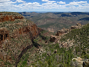
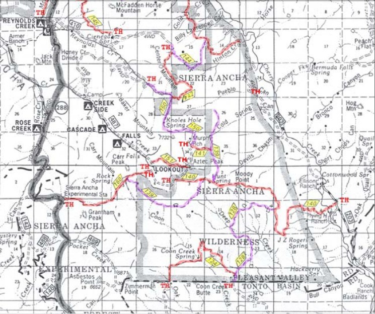
.. An amAZing Journey to the Edge .. by Grasshopper   Overview OverviewThis most enjoyable full-day outing in our remote and rugged Sierra Ancha Wilderness begins with a very scenic drive on Hwy 288 to FR487- Workman's Creek Road past the popular photo stop at Workman Creek Falls, to the end of FR487A at the historic Murphy Ranch with its large apple orchard and building complex. TH Parking and Hike-Start are at the end of this FR487A. This special in and out hike with connecting trail options available takes you by the upper end of colorful, rugged with sheer cliff walls "Cold Spring Canyon" and then on to end at the beautiful high cliffs (+1000 ft drops), scenic, and rugged upper "Pueblo Canyon Bluff Overlook" area for near and distant views of the Cherry Creek Drainage to the east and north. Also included in this day hike or overnight(s) backpack option is a short 0.1-mile round trip hike to perennial Edward Spring seep with its surrounding overnight campsite options. Warning Hiking is within an elevation high of 7250 feet and low of 6250 feet with 80% sun and elements exposure (most exposure due to the devastating YR2000 Coon Creek Fire and associated new growth on a large portion of this trail hike). Due to this exposure with our Arizona summer Monsoon Season, with lighting strikes possible, it is essential to take the weather conditions seriously before attempting a hike in this area.
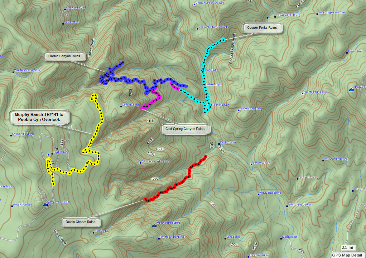
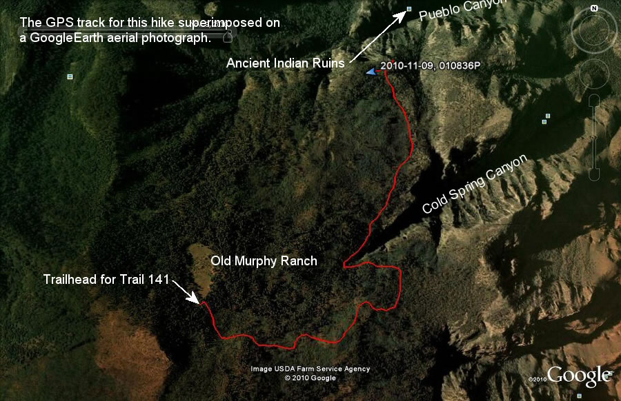
For your convenience and use, please review (info and route detail) and download the two referenced GPS Routes attached to this hike description: "Dive to Pueblo Cyn Overlook TH Parking" and the default hiking route- "Pueblo Cyn Overlook via Murphy Ranch#141. This hike begins on signed Murphy Ranch Trail #141 at the FR487A road end TH Parking area as noted in the driving directions section and further detailed in my posted 5/15/10 pic set and GPS Route. Trail#141, with some manageable tree downfall and overgrowth to negotiate on the trail, is relatively well defined, easy to follow, and continues downhill for ~1.1 miles to end and intersect "Rim Trail#139" north and south. This hike continues north (left turn) on Rim Trail #139 to first views of scenic and rugged upper "Cold Spring Canyon" drainage at ~1.7 miles in from TH Start. After rounding the scenic upper end of this canyon on TR#139, you continue NE on the trail along the north side of upper Cold Spring Canyon to a recommended short-downhill "off-trail" section (no signage or cairn) at ~1.84 miles in from TH Start (at reference waypoint N33.82588 W110.89301). This short-down hill "off-trail" segment takes you to a most scenic bluff overview section of middle-lower Cold Spring Canyon drainage and Cherry Creek drainage beyond. Continue hiking northeast then north on Rim Trail#139 with some manageable tree downfall and minimal trail overgrowth on this relatively easy and well-defined trail section. At ~2.90 miles in from TH Start, you will arrive at the signed intersection for perennial "Edward Spring" seep and "Pueblo Canyon Bluff Overview" area. The author suggests you hike the short 0.1-mile round trip distance to enjoy the riparian area of perennial Edward Spring (seep at waypoint N33.83651 W110.89256) before enjoying the more time consuming- scenic photo and break locations along the upper Pueblo Canyon Rim view areas (beginning at waypoint N33.83742 W110.89124). Water Sources Edward Spring: Perennial seep suitable for drinking water filtration or chemical treatment. Camping Backpacking tent and hammock camping locations are readily available.
Check out the Official Route and Triplogs. Leave No Trace and +Add a Triplog after your hike to support this local community. | |||||||||||||||||||||||||||||||||||||||||||||||||||||||||||||||||||||||||||||||||||||||||||||||||||||||||||||||||||||||||||||||||||||||||||||||||||||||||||||||||||||||||||||||||||||||||||||||||||||||||||