 Route Editor

| Guide | ♦ | 30 Triplogs | 0 Topics |
details | drive | permit | forecast | 🔥 route |
stats |
photos | triplogs | topics | location |
| 192 | 30 | 0 |
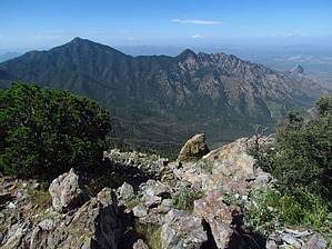
Wrightson's little brother by RedwallNHops  When most people travel to the Santa Ritas, they go for the high point, 9453ft Mt Wrightson. That leaves gems like McCleary peak for the rest of us. At 8357 feet, McCleary doesn't get Wrightson's attention, but it is a fantastic destination. When most people travel to the Santa Ritas, they go for the high point, 9453ft Mt Wrightson. That leaves gems like McCleary peak for the rest of us. At 8357 feet, McCleary doesn't get Wrightson's attention, but it is a fantastic destination.This hike leaves from the Roundup trailhead at the end of Madera Canyon road. Start on the Super Trail. Follow the Super trail 1/4 to 1/2 mile until you see a well-defined route on your left(north). This is the unofficial "Pipeline Route." Follow this steep, narrow, but well-defined route as it follows a pipeline until it dumps you out onto the Kent Spring trail near Sylvester spring. Follow this VERY steep trail(more like a jeep road) approx 1 - 1.5 miles until you reach Kent Spring.
On the north side of the saddle, look for a route climbing up to the north. The route is not particularly well-defined, but it is followable. There is a smattering of cairns to help you out. Keep mostly to the top of the ridge, and you should be fine. The top is a rocky exposed summit with great views of the rest of the range and the surrounding area. Go back down the way you came. Continue down the Four Springs trail as it switchbacks its way down the burned slopes. After about 0.5 miles, you come to the Crest Trail junction. Take a right here. Follow the Crest Trail about 3.2 miles as it makes it's way to Baldy Saddle. From there, it is another 4.5 miles back to your vehicle via the Old Baldy trail. Check out the Official Route and Triplogs. Note This is a moderately difficult hike. Leave No Trace and +Add a Triplog after your hike to support this local community. | |||||||||||||||||||||||||||||||||||||||||||||||||||||||||||||||||||||||||||||||||||||||||||||||||||||||||||||||||||||||||||||||||||||||||||||||||||||||||||||||||||||||||||||||||||||||||||||||||||||||||


