Strawberry Crater, AZ | HikeArizona
username
X
password
register
for free!
help
 
  🔥

Strawberry Crater, AZ

Guide 8 Triplogs  0 Topics
  3.8 of 5 
Fav
Wish
2
details
drive
no permit
forecast
🔥
route  
stats
photos
triplogs
topics
location
34 8 0
HAZ reminds you to respect the ruins. Please read the Archaeological Resources Protection Act of 1979 & Ruins Etiquette
Statistics
tap icons for details
Difficulty 1.5 of 5
Route Finding 2 of 5
Distance Lasso-Loop 1.9 miles
Trailhead Elevation 6,121 feet
Elevation Gain 204 feet
Accumulated Gain 411 feet
Avg Time Round Trip 2 hours
Kokopelli Seeds 3.96
 Interest Ruins & Historic
 Backpack No
 Dogs not allowed
feature photo
Photos Viewed All MineFollowing
Inaugural Calculation on Button Tap!
9  2022-10-17 GrangerGuy
12  2011-10-03 Stoic
10  2009-05-21 conform6073
3  2008-05-11 fotogirl53
Author
author avatar Guides 24
Routes 90
Photos 614
Trips 67 map ( 768 miles )
Age 66 Male Gender
Location Phoenix, AZ
Associated Areas
list map done
Flagstaff Region
Historical Weather
Trailhead Forecast
Radar Map
Expand Map
Preferred May, Aug, Sep, Oct
Seasons   Late Spring to Early Autumn
Sun  6:37am - 6:33pm
Official Route
 
0 Alternative
 
 Water
Historic Fire Perimeteracres
🔥 2022-04-29 Tunnel60.4 mi*


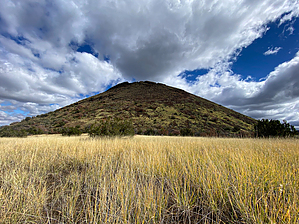
A taste of wilderness
by GrangerGuy

 
Overview
The only trail in the Strawberry Crater Wilderness just touches the northwest corner of the wilderness, albeit the most interesting part. The trail explores the outside and inside of the crater, crossing over the rim at a couple of low points. There are ruins in the area, but to find them, you will have to explore off-trail.


Hike
Although the sign at the trailhead says the hike is 1 mile, it is really about 1.9 miles. From the parking area, the trail heads straight toward the mountain, becoming increasingly vague as you travel the first few hundred yards. At one point, the trail appears to fork, but stay to the right, and you will soon come to a signed junction where the loop trail around the mountain goes left and right.

Proceeding to the left, clockwise around the loop, the path remains clear as it climbs gently up the left shoulder of the extinct volcano, passing through fields of Apache plume and grasses punctuated by scarlet gilia. The path tops out at 6130 feet and then drops into the crater, which is completely open to the east.


Follow the trail into and across the crater, and it soon switchbacks up to a second pass at around 6325’. Proceeding down around the southern outside of the volcano, the path traverses across a steep scree slope, and then into a grassy area where it may be a little hard to follow. Don’t be tempted to take the steep use-trail down the scree slope but instead continue on a gentle downward traverse as it contours around the mountain, eventually rejoining the trail to the parking lot.

Check out the Official Route and Triplogs.

Leave No Trace and +Add a Triplog after your hike to support this local community.

2022-10-19 GrangerGuy
    WARNING! Hiking and outdoor related sports can be dangerous. Be responsible and prepare for the trip. Study the area you are entering and plan accordingly. Dress for the current and unexpected weather changes. Take plenty of water. Never go alone. Make an itinerary with your plan(s), route(s), destination(s) and expected return time. Give your itinerary to trusted family and/or friends.

     Permit $$
    None


     Directions
    or
    or
     Road
    High Clearance possible when dry

    To hike
    Take AZ-89 north from Flagstaff to just past milepost 434. Turn right on FR-546, traveling continually eastward. Eventually, the road becomes FR 779 and then arrives at the trailhead parking after crossing a high voltage power line right of way, about 5.5 miles from the highway.
    page created by joebartels on Oct 19 2022 2:24 pm
    helpcorrectionissue

    end of page marker