 Route Editor

| Guide | ♦ | 22 Triplogs | 0 Topics |
details | drive | permit | forecast | 🔥 route |
stats |
photos | triplogs | topics | location |
| 301 | 22 | 0 |
Canyons are inherently risky. Flash floods occur without notice on sunny days. Technical skills & surrounding topography knowledge required yet does not eliminate risk.
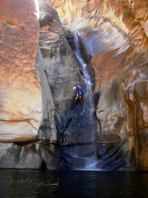
Worth the long haul by nonot  Overview OverviewA technical canyon in the middle of the Santa Catalinas. Warning Canyoneering involves traveling through slot canyons where flash floods are a definite possibility. Always check the weather before you depart and do not go if there is any chance of rain. For this technical trip, you will need to bring appropriate gear, which will include: harness, helmet, rappelling device and several locking biners, 7 rap rings, 80 ft webbing, and 2x200 ft ropes. A wetsuit will be warranted most of the year. Even at 108 highs in Tucson, most will want at least a shorty wetsuit. This canyon is long, start early and keep up your energy level by snacking. Most time will be spent going 0.4 miles in the technical section which will take you 5-9 hrs alone. Another mile of canyon hopping, 4 miles of road, and 8 miles of trail complete the day's totals.
Beta for this canyon trip was obtained from Todd Martin's book: "Arizona, Technical Canyoneering". The book also lists several other options to do this canyon, along with other excellent information, which are not listed in this hike description. The book does have a few minor errors, which are noted below. Hike From the Palisades Trailhead, head down the Palisades Trail. The trail is mostly downhill and you should be able to make fairly good time. Palisades trail follows a ridgeline downhill and begins to parallel Pine Canyon on the southeast side of the ridge. It will leave a drainage of Pine Canyon and begin crossing over the ridge to the north side when it enters a large rock plateau. Descend several switchbacks until the trail begins tracking west. After 4.4 miles and approximately 1.5 hours on the Palisades trail, you will have reached a gully that allows access down into Palisades canyon. Drop down the gully into the canyon and gear up on the conveniently located ledges. Beware of snakes in the area! Follow the creek downstream a short distance around the corner and through the pool to the first rappel (R1), approximately 150 ft through a small pool and over a large drop. The rappels are slippery and most will be unable to maintain their footing on this (or any) rappel in Palisades Canyon. The anchor for this first rappel was sketchy, evaluate it carefully as it may be necessary to rebuild or relocate it. The next 4 rappels do not generally even require you to coil your rope as they come in rapid succession. (R2): 100 ft down a sculpted shoot under a rooster tail, into a large plunge pool with swimming disconnect. (R3): Approx 85 ft (100 ft+ rope needed, plus another 100+ft for pull side) from 2 pitons in cracks on the left LDC. (R4): 100 ft from a boulder in the watercourse...an error of omission in the guidebook Climb down a small waterfall on left LDC (R5): Approx 100 ft from 2 pitons on right LDC. The anchor is back from the edge, so you may need slightly more than 200 ft of rope. The boulder in the shallow pothole is another possibility suggested in the book but may require digging to gain a good lip due to sedimentation based on its condition as found in late summer 2010. After the bottom of R5 is a nice flat ledge system that you can look back up canyon at the last 4 rappels that descended over 400 ft. Don't miss this view! Pack up the ropes and continue down canyon for about 15 minutes of rock hopping. (R6): A complicated double rappel over a possibly downclimbed drop and down the main waterfall. I recommend you go straight over the lip of the falls as the ropes run better this way from below. The combined drops are approximately 160ft. A bit of a walk down canyon brings you to the final rappel. Be warned that this final rappel has a reputation for sticking ropes. I recommend selecting several half-inch to inch diameter stones to place in the crack at the pinch point to help prevent this problem. (R7): 85 ft to the right of the waterfall over two overhung edges. A swimming disconnect may be required. Have the first person down test the pull before the last person rappels. From here de-gear and hike, boulder, and downclimb Palisade Canyon until you reach the (faint) West Fork Trail. Go east about 0.1 miles on the West Fork Trail to reach the junction of West Fork, East Fork, and Sabino Canyon trails. Take the Sabino Canyon trail up a small hill and follow Sabino Canyon Trail southwest. The trail is easy walking and soon you will reach the tram stop. Hike down the road another 4 miles to your shuttle vehicle at Sabino Canyon TH. Water Sources Palisades Canyon will have water, although it disappears in sections between the final rappel and the junction with West Fork Trail. Camping Popular in the Sabino Canyon Basin area, where you will pick up the trails at the end of the canyon. Check out the Official Route and Triplogs. Leave No Trace and +Add a Triplog after your canyon trip to support this local community. | ||||||||||||||||||||||||||||||||||||||||||||||||||||||||||||||||||||||||||||||||||||||||||||||||||||||||||||||||||||


