 Route Editor

| Guide | ♦ | 39 Triplogs | 0 Topics |
details | drive | permit | forecast | 🔥 route |
stats |
photos | triplogs | topics | location |
| 260 | 39 | 0 |
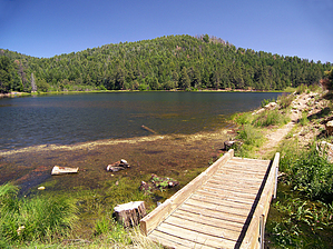
 Overview OverviewThe Lakeshore Trail #340 circles around Riggs Lake (a.k.a. Riggs Flat Lake), in southeastern Arizona's Pinaleno Mountains. This loop hike next to a beautiful mountain lake makes for a brief and easy outing and is easy enough for small children to hike. This trail is popular with fishers and campers because of its proximity to Riggs Lake and Riggs Flat Campground. History Riggs Flat, where the lake is today, was once the home of the Riggs family. The Riggs' were early inhabitants of the Pinaleno Mountains, who built a log cabin and grew potatoes in this high mountain valley. Long after the Riggs family abandoned their mountain top farm for the Sulphur Springs Valley, the Arizona Game and Fish Department constructed a dam at the lower end of Riggs Flat, creating Riggs Lake in 1957.
Do not park your vehicle in a Riggs Flat Campground campsite, or you will be subject to the camping fee. Hike No signs identify this trail, but it is easy to follow as it sticks close to the shoreline of Riggs Lake. From the end of the campground, where the road makes a 180 degree turn to the left, a concrete walkway heads off to the right, towards the wooded lakeshore. After passing a popular fishing spot, the walkway turns to dirt, and the Lakeshore Trail straightaways across Riggs Lake's earthen dam. The trail crosses a little wooden bridge over the spillway before reentering the coniferous forest bordering the waterfront. As you are rounding the north shore, the trail becomes a narrow footpath that ambles among tall ferns and marshy inlets. The fire-scarred summit of Merrill Peak rises above the lake to the south. Turning south, you cross a marshy area, where a nameless creek supplies the lake's water. Alder thickets and giant leaved cow parsnip plants crowd the trail here. The trail soon reaches the broad, grassy, south shore of Riggs Lake, near the campground, where many people enjoy fishing. The boat ramp and parking lot soon come into view, where this short little hike comes to an end. Check out the Official Route and Triplogs. Leave No Trace and +Add a Triplog after your hike to support this local community. | ||||||||||||||||||||||||||||||||||||||||||||||||||||||||||||||||||||||||||||||||||||||||||||||||||||||||||||||||||||||||||||||||||||||||||||||||||||||||||||||||||||||||||||||||||||||||||||||||||||||


