Route Editor

| Guide | ♦ | 72 Triplogs | 5 Topics |
details | drive | no permit | forecast | 🔥 route |
stats |
photos | triplogs | topics | location |
| 913 | 72 | 5 |
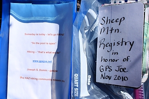
In memory of gpsjoe by John10s   History HistorySheep Mountain was the destination of HAZ member Joe Domin (gpsjoe) when he set out on a solo hike in November 2010. He never returned from the hike; his vehicle was recovered from the trailhead, and despite extensive search and rescue efforts that included many volunteers from the HAZ community, gpsjoe was never found. As of 2023, his missing poster still sits behind the plastic of the main sign at Peeley Trailhead, and the summit register on Sheep Mountain is full of entries from SAR volunteers and hikers looking for gpsjoe over the years. Overview Sheep Mountain is accessible via an off-trail hike along a rugged ridgeline that starts on the southwest side of Mt. Peeley and continues ~1.5 miles to the summit of Sheep Mountain at 6,996'. Pants, gloves, and protective clothing will come in handy while navigating the brushy terrain along the ridge, which includes multiple small false summits and rock outcroppings along the way. Although the mileage and AEG are relatively modest, the constant brush and the ups and downs along the ridgeline make the hike feel more difficult than the numbers suggest.
The hike begins at Peeley Trailhead at the end of FR 201. Start following Cornucopia Trail #86, which intersects Mazatzal Divide Trail #23 after roughly a half mile. Cornucopia branches off to the left; continue straight to stay on Mazatzal Divide, which climbs through a short series of switchbacks and steadily gains elevation over the next mile and a half. The trail tends to be well maintained, as it's AZT segment #23. Around two miles in, a large cairn marks a use trail that branches off to the south toward Mt. Peeley. Consider adding a detour to the summit of Peeley on the way to Sheep Mountain; by dropping down the west side of Peeley after leaving the summit, you can reconnect with the Sheep Mountain route without adding significant distance to the hike. Check out the triplogs and the official guide for Mt. Peeley for more details about this option. Otherwise, continue on Mazatzal Divide Trail as it turns south around the west side of Peeley, entering a more heavily forested area. Around 2.6 miles in, leave the trail to start making your way toward the ridgeline. This area has significant deadfall from past fire damage that may slow the pace, but the terrain isn't too steep. After reaching the ridgeline, the route becomes a rollercoaster of ups and downs over multiple rock outcroppings, with thick manzanita and brush along the way. Although navigating some of the outcroppings may look challenging from a distance, it's generally easiest to do the minor scrambling needed to go up and down the rocks, which is easier than fighting the brush and steep slopes along the sides. Route finding tends to be straightforward along the ridgeline, with the higher peaks visible from most of the higher points along the way. Behind you to the north, Peeley, Mt. Catherine, Mazatzal Peak, and Peaks 7532 and 7579 dominate the horizon, and Peak 6910 and Sheep Mountain are the larger peaks to the southwest, though they come in and out of view during the ups and downs along the way. Peak 6910 is the second-highest peak along the ridge, and you can pass to the west on the way to Sheep Mountain. After a few more minor obstacles, the brush finally opens up a little before the final ascent to the summit, where you'll find the summit register full of HAZ and SAR names and notes about the search for gpsjoe, including a copy of his planned route that day. Looking back along the ridgeline to the north you'll see the aforementioned peaks and the view to the south includes landmarks such as Saddle Mountain, Bartlett Reservoir, the McDowells and Superstitions, Four Peaks, the Estrellas, and more. Depending on the time of year, expect to find a large population of ladybugs at the summit. After enjoying the peak and bracing yourself for a repeat battle with the brush, you can return via the same route along the ridgeline, eventually reconnecting with Mazatzal Divide Trail back to the trailhead. Check out the Official Route and Triplogs. Leave No Trace and +Add a Triplog after your hike to support this local community. | ||||||||||||||||||||||||||||||||||||||||||||||||||||||||||||||||||||||||||||||||||||||||||||||||||||||||||||||||||||||||||||||||||||||||||||||||||||||||||||||||||||||||||||||||||||||||||||||||||||||||||||||||||||