 Route Editor

| Guide | ♦ | 7 Triplogs | 0 Topics |
details | drive | permit | forecast | route |
stats |
photos | triplogs | topics | location |
| 35 | 7 | 0 |
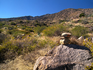
  This abandoned trail climbs Dutch Henry Canyon on the southeastern edge of the Pinaleno Mountains and connects with the Bear Canyon Trail #299 on its upper end. The Dutch Henry Trail is quite scenic, beginning in mesquite-grassland, and ending in a nice pine-fir forest at the top. The canyon has been spared from recent devastating wildfires. The Dutch Henry Trail is in very poor condition, is nearly overgrown, and exists mostly as a sparsely cairned route. I'd say route-finding and difficulty are both a 4. Plan on an entire day for a one-way hike. The upper trailhead on Highway 366 is accessible by car at Ladybug Saddle, while the lower trailhead is 4x4, due to sandy washes. -Preston Sands, Nov. 23, 2010 This abandoned trail climbs Dutch Henry Canyon on the southeastern edge of the Pinaleno Mountains and connects with the Bear Canyon Trail #299 on its upper end. The Dutch Henry Trail is quite scenic, beginning in mesquite-grassland, and ending in a nice pine-fir forest at the top. The canyon has been spared from recent devastating wildfires. The Dutch Henry Trail is in very poor condition, is nearly overgrown, and exists mostly as a sparsely cairned route. I'd say route-finding and difficulty are both a 4. Plan on an entire day for a one-way hike. The upper trailhead on Highway 366 is accessible by car at Ladybug Saddle, while the lower trailhead is 4x4, due to sandy washes. -Preston Sands, Nov. 23, 2010If anyone completes this trail, please submit a full hike description. Check out the Official Route and Triplogs. Note This is a moderately difficult hike. Leave No Trace and +Add a Triplog after your hike to support this local community. One-Way Notice This hike is listed as One-Way. When hiking several trails on a single "hike", log it with a generic name that describes the hike. Then link the trails traveled, check out the example. | ||||||||||||||||||||||||||||||||||||||||||||||||||||||||||||||||||||||||||||||||||||||


