Route Editor

| Guide | ♦ | 1 Triplog | 2 Topics |
details | drive | permit | forecast | 🔥 route |
stats |
photos | triplog | topics | location |
| 13 | 1 | 2 |
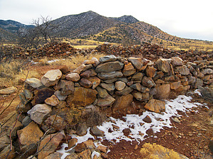
short hike, long history by PrestonSands   Overview OverviewThe historic Dragoon Springs Stage Station, on the northern edge of the Dragoon Mountains, is a site full of western history and brutal violence. The hike to its ruins, although exceedingly short, is worth the effort if you are in the area. One can also hike beyond the stage station ruins up Jordan Canyon to Dragoon Spring itself. History In 1857, John Butterfield, after being awarded a government mail contract, constructed a stagecoach route that came to be known as the Butterfield Trail, between St. Louis and San Francisco. The route crossed southern Arizona, and stagecoach stations were constructed every twenty miles or so along the route, taking advantage of dependable water sources when possible. Dragoon Springs was one of these sources, and a station was constructed near the springs in August 1858. The heavily fortified station consisted of a 3 foot thick, 10 foot high stone wall, 45 feet by 55 feet enclosing the site, with two small rooms inside the enclosure. The stock was corralled within the walls.
A Confederate Army foraging party gathering stray cattle was attacked at Dragoon Springs on May 5, 1862, by Apaches under Cochise and Francisco's command. Four Confederate soldiers were killed and buried at the stage station. Their graves can be seen today. Several days after the famous Council Rocks peace meeting between Cochise and General Howard near the mouth of Stronghold Canyon West, a formal meeting was held at Dragoon Springs on October 12, 1872. It was here that the boundaries of the new Chiricahua Apache Reservation were laid out. The Reservation extended east to New Mexico and south to Mexico and included the Dragoon Mountains. The Reservation was short-lived, only lasting until 1876. Hike First, locate the Dragoon Springs Stage Station sign next to the road (1.1 miles up Forest Road 4232 from Old Ranch Road and 0.7 miles past the signed Coronado National forest boundary). Begin hiking up the path that departs from behind the sign. The path travels north, climbing a low grassy rise, and crosses through a fence along the way. The path quickly arrives at a large, rectangular rock wall, maybe 4 to 5 feet high. This is the ruin of the stage station. A few yards further north are the graves of the Confederate soldiers. Several interpretive plaques inform visitors of the site's history. Visible to the north is Dragoon Pass and the Texas Canyon area. Immediately to the south and east, the Dragoon Mountains rise from the surrounding plains. Return the same way. One can also continue hiking (or driving) for another mile along Forest Road 4232 to the Dragoon Springs area in Jordan Canyon. A rock wall among the oak trees in the wash may be Dragoon Spring. If so, it is in disrepair, as I did not see any water. A well-beaten cow path heads up Jordan Canyon for aways before fading away. Check out the Official Route and Triplog. Leave No Trace and +Add a Triplog after your hike to support this local community. | ||||||||||||||||||||||||||||||||||||||||||||||||||||||||||||||||||||||||||||||||||||||||||||||||||||||