Route Editor

| Guide | ♦ | 9 Triplogs | 1 Topic |
details | drive | permit | forecast | 🔥 route |
stats |
photos | triplogs | topic | location |
| 118 | 9 | 1 |
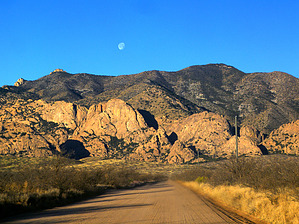
  Overview OverviewMt. Glenn is the highpoint of the fabulous Dragoon Mountains in southeast Arizona. It sits at roughly 7519 feet and provides 360-degree panoramic views of much of southeast Arizona, with visibility extending into New Mexico and Mexico as well. This ski island range has few trails, aside from the famous Cochise Stronghold area, and a trip to the summit of Mt. Glenn is a 100% off-trail bushwhack that requires good fitness and reliable route-finding skills. Warning A trip to the summit of Mt. Glenn is tremendously rewarding but quite difficult and will likely come at a price. There is no trail or route, it's all off-trail scrambling through brush along a prominent ridgeline. There are infinite sticky, pointy, sharp things with occasional loose footing. Near the top, the brush is almost impenetrable for the last short stretch. There will certainly be bloodshed on this trip. Also being a pure bushwhack, one must familiarize themself with the terrain and know the route by map. This description will provide a basic route along the northeast ridgeline leading to the summit, but is no more than that. Your route and obstacles will, by nature, be unique to your trip. Finally, as the last warning, the descent can be disorienting at the top. From the summit, the initial descent is through an incredibly thick brush with little to no visibility. Becoming seriously disoriented is very easy and this can lead to trouble; thus a GPS is very, very helpful for this trip.
From the parking area along the primitive road, you can see the easternmost end of the prominent northeast ridge leading up to Mt. Glenn. Head cross country to the ridge. There is a prominent saddle you can head for or you can angle west a little and just go straight up the slope to the first highpoint west of the saddle, either way, you need to climb up and access the ridge to climb Mt. Glenn. The slope of the ridge is composed of loose footing, endless grass, and hidden cacti, agave, etc. It is also quite steep. Once on the ridgeline, you are greeted with sensational views south over to the Stronghold and the breadth of the Dragoon Mountains. These wonderous views will accompany you much of the way. On the ridge you will see the route in front of you to the west, then gradually the southwest, as a long ridge spilling down from the forested summit of Mt. Glenn. The ridge is composed of a series of intermittent highpoints and climbs, interspersed with a few tiny descents to saddles, before resuming tough climbs. Some of the highpoints have old massive cairns on them and some do not, there is no trail whatsoever, so the route you choose is the path of least resistance. The north end of the ridge is typically more brushy and dense, so it may benefit you to just stay on the ridge and much as possible and veer south when necessary to the drier side if need be. The stabbing along the way will be endless. A couple of prominent high points to look out for include points 6241 and 6841. Just after point 6841, a brief descent to a saddle will place you in front of an unusual prominent band of rock you find a way past. Either trying to climb over or scramble around the south end will work, though each presents a challenge and some sketchy footing. Once past this obstacle, the last stretch presents itself as a couple more ascents, then the forest. The last exposed climb before the forest closes in is probably the steepest and toughest for route finding. Just after this is the final leg. The oaks and pinons close in and the scrambling becomes like trying to walk through a brick wall at times. Gouging and stabbing mix with no visibility to become disorienting. This last stretch is not long but will feel like it. The best you can do is stay as close to the ridge as possible and head for any open light you can see. There is a very good chance you will finally encounter a small cliff band cutting diagonally across the slope. You will need to go over this. It is possible to cross it in a couple of places, but each requires special care and attention...this is NOT the place to fall. Once across this cliff, it is only a few more hundred feet to the top, albeit incredibly brushy. From the top, the views will immediately make your effort worthwhile as endless views in every direction seem to go on forever. The Willcox playa will amaze you with its size and starkness. The Cochise Stronghold is also just unbelievable from this vantage. The Rincons, Chiricahuas, Dos Cabezos, Pinalenos, Huachucas and Mt. Lemmon are all visible among others. The trip down requires special care and attention to make it through the brushy forest, as well as all the loose footing along the way. Please be careful when attempting Mt. Glenn and take the challenges it presents seriously. It is an incredible peak to summit. Check out the Official Route and Triplogs. Note This is a moderately difficult hike. Leave No Trace and +Add a Triplog after your hike to support this local community. | ||||||||||||||||||||||||||||||||||||||||||||||||||||||||||||||||||||||||||||||||||||||||||||||||