Route Editor

| Guide | ♦ | 48 Triplogs | 1 Topic |
details | drive | no permit | forecast | route |
stats |
photos | triplogs | topic | location |
| 586 | 48 | 1 |
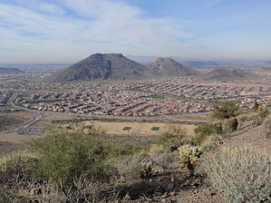
The Best View by MEWhiteman  Overview OverviewThis is a nice hike in the Phoenix area, offering hills and views and a well-maintained trail. It is easy to get to and has numerous trails allowing for a variety of hikes. I have used the names of the trails given in the map posted at the trailhead. On many planning maps, the trails are numbered, and I have included those numbers. Some numbered segments have previously been described on HikeAZ as individual hikes. The is comprised of trails or segments of trails previously numbered 1, 2, 3, 4, 5, and 6. Hike From the parking, find the Circumference Trail (Trail 1) at the parking lot's west end. Follow the trail uphill for about 0.6 miles to a junction (N33 43.793 W112 08.874) with the Basalt Trail. Turn right. At about 0.7 miles (N33 43.838 W112 08.943) is another junction. Turn left here onto the Paradise Trail (Trail 2). At about 0.8 miles (N33 43.796 W112 09.023), you come to another junction with the Paradise Trail, where you should keep right. At 1.0 miles (N33 43.710 W112 09.186), go straight through this junction onto the Ridgeline Trail (Trail 5). This trail winds up to near the highest point in this park, providing some great views in most directions. It's a good place for a snack.
Turn right here and follow the Paradise Trail to the junction with the Circumference Trail at about 4.2 miles (N33 43.572 W112 08.567), passing two trails to the left on the way that are cutoffs to the Circumference Trail, which would shorten your hike a little. Turn left onto the Circumference Trail, passing the other ends of the two cutoff trails. At the junction with the Basalt Trail at 4.6 miles (N33 43.793 W112 08.874), turn right to stay on the Circumference Trail back to the parking area. The total distance is about 5.0 miles and 1,100 feet of AEG. This hike can be confusing in places because there are several trails and junctions, and at the time I did the hike, none had any signage indicating what trail you were on or what trails went where at each intersection. There is a map showing the trail names at the trailhead. A GPS track is beneficial. I've tried to describe the turns to make it easier to follow without a GPS, and hopefully, the city will put signs up in the future. Check out the Official Route and Triplogs. Leave No Trace and +Add a Triplog after your hike to support this local community. | ||||||||||||||||||||||||||||||||||||||||||||||||||||||||||||||||||||||||||||||||||||||||||||||||||||||||||||||||||||||||||||||||||||||||||||||||||||||||||||||||||||||||||||||||||||||||||