 Route Editor

| Guide | ♦ | 146 Triplogs | 0 Topics |
details | drive | no permit | forecast | route |
stats |
photos | triplogs | topics | location |
| 316 | 146 | 0 |
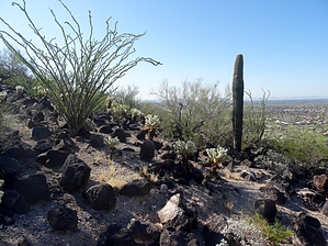
It's all about that Bass-alt by Barrett  Smack dab in the middle of Deem Hills Recreation Area, the Basalt Trail serves as a connector between several of the longer trails in the park and does not originate at either of the main trailheads. The first access is from the west via the Deem Hills Park trailhead, which has bathrooms, drinking fountains, and several ramadas, by taking the Circumference Trail 0.87 miles along its southern path. This will land you roughly in the middle of the Basalt trail. To start at the "trailhead" shown on the map, you can take the Circumference trail's northern path for 2.1 miles. The second access is from the east via the East Trailhead, which has only drinking fountains and a small ramada, by taking the Circumference Trail 0.59 miles. For this description, I will use the eastern approach, as it is the quickest way to get to the Basalt. Smack dab in the middle of Deem Hills Recreation Area, the Basalt Trail serves as a connector between several of the longer trails in the park and does not originate at either of the main trailheads. The first access is from the west via the Deem Hills Park trailhead, which has bathrooms, drinking fountains, and several ramadas, by taking the Circumference Trail 0.87 miles along its southern path. This will land you roughly in the middle of the Basalt trail. To start at the "trailhead" shown on the map, you can take the Circumference trail's northern path for 2.1 miles. The second access is from the east via the East Trailhead, which has only drinking fountains and a small ramada, by taking the Circumference Trail 0.59 miles. For this description, I will use the eastern approach, as it is the quickest way to get to the Basalt.After an elevation gain of approximately 300 feet along the Circumference Trail, you will arrive at 33.729893N -112.147908W, marking the eastern terminus of the Basalt trail. There you will find a convenient trail marker that shows a trail profile, GPS coordinates, even a scannable QR code that will provide trail information on your smartphone. Follow the arrow right for 0.11 miles until you reach another marker telling you to turn left. For the next 0.1 miles, you will be on a combination of the Palisade and Basalt Trails, until you reach another marker where the Palisade Trail departs to the left and you continue on the Basalt proper. The view will open up to the inner basin, with an interesting section of black basalt rocks sitting on a light-colored area loaded with Chalcedony, fine-grained quartz prized by ancient inhabitants of the area that can be shaped into arrowheads, knives, and scrapers. After 0.22 miles you will reach a 4-way intersection, with the Circumference trail on your left, Ridgeline straight ahead, and Basalt to your right. Take a right and continue 0.1 mile, to 33.730144N -112.153550W, the western terminus of Basalt at yet another intersection with the Circumference trail.
Basalt is an igneous rock that in this area was formed by volcanic activity 2-5 million years ago. As the lava cooled, it fractured into the boulders you see covering most of the ground. Originally reddish-brown, the black coating, called desert varnish, is formed in arid climates over thousands of years on the exposed rock by a combination of chemical processes and microbes, and is made primarily of manganese. Another geologic feature that can be seen along this trail is exposed by the displacement of boulders to make the trail. A white crust, called a carbonate skin, is seen on the surface that was below ground. This coating also only forms in arid climates and is the result of accumulation of usually calcium carbonate attaching to the stone as moisture moves up and evaporates through the soils surface. While not the most dramatic trail in the park, the Basalt ties everything together and gives the hiker a front-row seat to some classic Sonoran Desert geology.
Check out the Official Route and Triplogs. Leave No Trace and +Add a Triplog after your hike to support this local community. One-Way Notice This hike is listed as One-Way. When hiking several trails on a single "hike", log it with a generic name that describes the hike. Then link the trails traveled, check out the example. | |||||||||||||||||||||||||||||||||||||||||||||||||||||||||||||||||||||||||||||||||||||||||||||||||||||||||||||||||||||||||||||||||||||||||||||||||||||||||||||||||||||||||||||||||||||||||||


