 Route Editor

| Guide | ♦ | 161 Triplogs | 0 Topics |
details | drive | no permit | forecast | route |
stats |
photos | triplogs | topics | location |
| 490 | 161 | 0 |
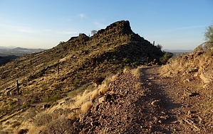
Ridged for your pleasure by Barrett  The most dramatic of the trails in the Deem Hills Recreation Area, the Ridgeline ascends the western end of the park, running along the ridge that contains the highpoint, but skirting the actual summit due to the tricky terrain. The most dramatic of the trails in the Deem Hills Recreation Area, the Ridgeline ascends the western end of the park, running along the ridge that contains the highpoint, but skirting the actual summit due to the tricky terrain.Two options will get you to the trail, the first being the Circumference Trail originating at Deem Hills Park, where you will find bathrooms, drinking water, a playground, and several ramadas. Follow the southern leg east 0.87 miles, climbing about 270' to a saddle and then down to the Ridgeline trailhead intersection at 33.728180, -112.152940, where you will find a convenient marker with GPS coordinates and a QR code that you can scan with a smartphone that will give you more information. The second option is to take the northern leg of the Circumference Trail 1.86 miles north and then east to loop around to the end of the Ridgeline Trail at 33.732071, -112.155903.
The flora is fairly sparse, with mostly Brittlebush and seasonal grasses, with a few Saguaros and small Palo Verdes thrown in. Depending on the time of year, the fauna can be pretty thin as well, with most birds during the day, and the snakes, lizards, scorpions, and the like only crawling around at night. The geology is some exposed basalt but without the variety seen along the actual Basalt trail, which connects the two ends of the Ridgeline trail and continues for a short distance to the east. For those interested, a very nice vantage point can be reached via boulder-hopping west from the north end of the Ridgeline trail. Though technically against park policy to leave the trail, the basalt boulders and a decent sense of balance can get you to a very nice flat boulder without leaving a trace. The same cannot be said of the off-trail required for the park's high point at the south end of the ridge, which will create use trails if people insist on bagging it. One more point of interest is a Hawks nest in a Saguaro right next to the trail at 33.732634 -112.159658. Originally made by Crows, Ravens, or Red-Tailed Hawks, the nest supports Great Horned Owls and their offspring during the Spring season. For a north Phoenix park, this trail sees less traffic than most, and the views, particularly to the north, are of undeveloped Sonoran Desert. The Ridgeline itself spends most of its time with no views of housing at all, so if you're looking for a bit of quiet, give it a shot.
Check out the Official Route and Triplogs. Leave No Trace and +Add a Triplog after your hike to support this local community. One-Way Notice This hike is listed as One-Way. When hiking several trails on a single "hike", log it with a generic name that describes the hike. Then link the trails traveled, check out the example. | ||||||||||||||||||||||||||||||||||||||||||||||||||||||||||||||||||||||||||||||||||||||||||||||||||||||||||||||||||||||||||||||||||||||||||||||||||||||||||||||||||||||||||||||||||||||||||


