Overview
Begins at the Holbert TH. Skirts the edge of the basin. Then ends at the Ranger Trail. The western end is accessed 0.25 miles up the Ranger Trail from Five Tables Trailhead.
Lomita is a low, broad hill.
Hike - From the East
The trail heads west adjacent to the paved road. After 100 yards, the road-hugging is over. You pass fenced-in utility equipment, then a large parking lot that rarely gets used.
0.35 mile The trail bends SW passing the South Mountain Environmental Education Center. The Official Route comes in handy for the next half mile due to various other trails.
0.82 mile Hike to this point was originally Box Canyon Loop Trail. Los Lomitas pre 2018ish originated near Scorpion Gulch and traveled through an undesirable sandy ravine. LL is now much easier to understand, taking the place of Box Canyon Loop.
1.12 mile Post #23. Cross the road to Piedras Grandes which translates to "large stones". Accessed just off this trail it is among my favorite SoMo locations. The history is rich, enjoy the ride...
Picnic Revolution
Other cities wanted the Arizona dream. 1950's Los Angeles commissioners said a park such as South Mountain would be worth ten million dollars to their coastal city. Phoenix paid $17k for the 14,513 acres in 1924.
Saddle and foot trails were expected eight miles south of the hustle and bustle of downtown in the 1930s. The park ventured beyond the call of duty catering to those seeking the comforts of the 20th century. Piedras Grandes, Las Ramadas & Las Lomitas ( view map ) were the Valley's hottest family scenes. These picnic areas had everything. Gravel and paved roadways led to ramadas. Loaded with features such as nearby water faucets, electric lights and fireplaces. Dance platforms were reserved for dancing(photo - Arizona Sun Bonnets at Las Ramadas Platform) and skating. In 1952 ramada tables cost 25 cents. Park entrance was free until 5 pm, then 25 cents per car thereafter. $0.25 in 1952 → $2.44 in 2020
Arroya Secco ( dry creek ) was a fourth picnic area with eight ramadas. The layout was slightly shuffled and now renamed "Three Tables" and "Five Tables" areas. A baseball field on old maps looks long gone based on satellite imagery.
1.30 mile Kiwanis Trail trailhead. From the previous section to here is blah but well defined and signed. Continuing west from Kiwanis, the trail immediately dips through the ravine that drains Kiwanis. Either the CCC did one hell of a job, or it received some love over the years. It's surely flashed at least once a decade since it was built in the 1930s.
The trail heads over towards the old Las Lomitas picnic area. Piedras is a mini Disneyland with all the rocks to play on. This is more of a large group area. Without the boulders, it just looks old. Yet better than Las Ramadas, my least favorite.
1.60 mile Cross the road to Las Lomitas and head towards the Ranger Trail. A little bleak for most. It has a nice small wash and a good distant view of the Estrella Range. About once every ten years, a nice wildflower display of poppies and lupine blanket this area through the Bajada Trail.
2.10 mile Trail ends at the Ranger Trail. It's under a quarter-mile to Five Tables, the TH for Ranger. For reference, to the northwest is a private track for the Quarter Midget Racing Association.
Synopsis
History of the Piedras area has fascinated me since the 90's. Most will see it as outdated to trashy now. You might have to play on the large stones and find the camera angles from years gone by to appreciate. I just wanted to share a little history of SoMo. It has unique areas that have been abused over the years. Park budgets are lean. Urban sprawl robs inner-city interests and monies.
2015-05-29 Published original. First 0.93 mi followed a sandy wash, then a destroyed horse trail.
2020-04-03 Revised for the new route. The first 0.82 mi now follows the previous Box Canyon Loop Trail. The first 0.82 mi, albeit blah, is actual trail vs. the previous nightmare.
When hiking several trails on a single "hike", log it with a generic name that describes the hike. Then link the trails traveled, check out the example.
WARNING! Hiking and outdoor related sports can be dangerous. Be responsible and prepare for the trip. Study the area you are entering and plan accordingly. Dress for the current and unexpected weather changes. Take plenty of water. Never go alone. Make an itinerary with your plan(s), route(s), destination(s) and expected return time. Give your itinerary to trusted family and/or friends.
Permit $$
None
Directions
Road
Paved - Car Okay
To hike Follow anywhere in the Valley north of South Mountain take Central Avenue south. Central Avenue curves a bit east then hard to the west as it enters the park. The eastern trailhead is the first parking lot on your right, directly north of Ponderosa Stables.
 Route Editor

 Overview
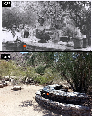


