Thumbing through a thesaurus for hours won't make the Ranger Trail sound appealing. The back trails of Piestewa Peak are thick forest compared to this lunar landscape.
Trailhead to Road 0.7mi / 290 ft
Hike through the frying pan. As you approach the mid-road crossing the trail gains some elevation.
Welcome to the bleakest spot on the face of the earth. Where it's so bad it's interesting. This is a stroll through the sunburnt rocks created by roughly ten thousand years of nothing but heat. Garbage greets you like the highway from Phoenix to Tucson. Nobody loses sleep over hiking this section of the trail. Nobody, it blows!
There is a positive side, even to this frying pan. Just come during a blazing wildflower season and you'll swear the bunnies are dancing.
Road to National Jnct +0.75 mi / +430 ft
Step up from awful to boring. The garbage comes to an abrupt halt. Obviously, losers are deceived by the looming mountain mass.
Fear not! This is lazy switchback country with only a mild grunt near the upper end. Even a fat dog like myself would have a fighting chance of mountain biking this trail. You definitely couldn't say the same for several others where five feet gains five feet!
There still isn't much of anything in the vegetation department. A few Palo Verdes take the show. One ocotillo, likely brushed by Moses, is so thick you could start a log cabin with the limbs. Saguaros wouldn't have anything to do with a northern slope, especially this one. Barrel cacti appear sun-scorched and twisted as if they're hurling.
Given all the bad you'd have to be blind to miss the lure. Inner-city, heck outer city, views don't get much better. Sunsets bounce orange to red and yellow in serious hues between Alta, Goat, and Butterfly peaks.
When hiking several trails on a single "hike", log it with a generic name that describes the hike. Then link the trails traveled, check out the example.
WARNING! Hiking and outdoor related sports can be dangerous. Be responsible and prepare for the trip. Study the area you are entering and plan accordingly. Dress for the current and unexpected weather changes. Take plenty of water. Never go alone. Make an itinerary with your plan(s), route(s), destination(s) and expected return time. Give your itinerary to trusted family and/or friends.
Permit $$
None
Directions
Road
Paved - Car Okay
To hike From Phoenix, head straight down Central, keep going and going until it hits South Mountain. The road curves west passing an entrance gate. From the entrance gate, it is exactly 1.0 mile to a left turn to Five Tables Picnic Area about 250 feet after turning. The turn is not permanently marked, temporary signs go up on occasion. There is a permanent sign to Three Stables just prior. If you turn here it quickly loops to Five Tables.
Central Ave turns into San Juan Rd in the park. If you come to a triangle island in the road you have gone too far. Which is where Summit Road branches left and San Juan continues straight.
0.5 mi after the entrance gate is a ranger / information / bathroom center. As with most if not all bathrooms in the park, the stalls are third-world open door deals. There is a water fountain and a soda vending machine with bottled water too.
 Route Editor

 Thumbing through a thesaurus for hours won't make the Ranger Trail sound appealing. The back trails of Piestewa Peak are thick forest compared to this lunar landscape.
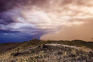


