Route Editor

| Guide | ♦ | 13 Triplogs | 0 Topics |
details | drive | no permit | forecast | 🔥 route |
stats |
photos | triplogs | topics | location |
| 126 | 13 | 0 |
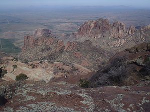
Forbes Route by nonot  Overview OverviewBabo is a hike and technical climb description for the Forbes-Montoya route. Warning Bring proper climbing gear, including helmets.
The Tohono O'odham Nation believes this mountain to be home of the creator, I'itoi. This deity turned ants into people, forming the first individuals of their nation. They believe he still watches over their people from his cave in the mountain. This will help explain some of the trinkets you find at the peak, which are offerings to their god. The tribe grants access to the mountain (with a permit) from the west side but ask all visitors to respect this place's sacred nature. The east side is currently not part of their territory and does not require permits. Hike From the ranch gate, you will hike up the road. Be sure to obey all trail signs as you are traveling over private property. Thankfully, as long as people stay on good behavior, access is being granted by the landowners. After you pass the ranch, the next mile or so of the trail is pleasant, wandering its way up the creek of Thomas Canyon. After 1.5 miles total, you will leave the creek and begin a series of steep switchbacks. It gets eroded at the top, and you run into fire-ravaged areas and a lot of dirt erosion slopes. It is easy to get off trail in a few places, so watch for cairns. When you get through the worst and finally arrive at the saddle, you will run into a climber campsite. There is no water here, but this is an excellent place to cache extra water you will only need for the hike back. From here, try to find the good trail that heads up the ridge to your west (and a bit north). You are aiming for the distinct notch in the mountain. Scramble up to the base of the notch. It is an off-trail romp up a gully. The first pitch is about 30 feet under a boulder. It is easy except for one, perhaps, 5.5 move. After this pitch, scramble up the rest of a gully and contour around (counterclockwise around the mountain) until you see a slabby slope. The second pitch is about 40 feet up this slab. It is perhaps a 5.1 climb. From the top of this pitch, walk up an exposed ridge and then turn toward the mountain and ascend slightly higher. However, from here, follow cairns to your right and down in elevation about 60 ft. Then go forward/left and back up about 50 feet to the base of the ladder pitch. This travel path goes around a 6 ft metal bar you see sticking out of a rock way above you. The third and final pitch is 100 ft. It zigzags a bit and goes about 5.3. Old bolts offer some protection placements, but the route is run out. From the top of this pitch, you can leave the rope and harness, and scramble perhaps 0.4 miles to the top - you will go to the right, then turn left up a gully, then around the mountain to your left, doing a half-circle around the mountain - look for signs of previous travel. I recommend you carry a GPS to track your path and not get lost on the way back down. The views from the top are magnificent. Return the way you came. Solid rappel anchors exist at the top of each climb. Water Sources The creek on the first 1.5 miles may have water. Camping A bivy spot exists at the saddle, but there is no water. Gate Policy: If a gate is closed upon arrival, leave it closed after you go through. If it is open, leave it open. Leaving a closed gate open may put cattle in danger. Closing an open gate may cut them off from water. Please be respectful, leave gates as found. The exception is signage on the gate directing you otherwise. Check out the Official Route and Triplogs. Leave No Trace and +Add a Triplog after your hike & climb trip to support this local community. | |||||||||||||||||||||||||||||||||||||||||||||||||||||||||||||||||||||||||||||||||||||||||||||||||||||||||||||||||