 Route Editor

| Guide | ♦ | 13 Triplogs | 0 Topics |
details | drive | permit | forecast | 🔥 route |
stats |
photos | triplogs | topics | location |
| 116 | 13 | 0 |
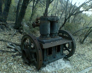
  This deep, narrow canyon offers hikers and horseback riders good views of the San Pedro Valley and the Mule Mountains near Bisbee. It leads into one of the most heavily mined areas of the Huachuca Range. The trail follows an old mining road for much of its length. It climbs into a canyon, which reputedly has been the site of prospecting activity since Spanish explorers visited the area in the mid-16th century. In the late 19th and early 20th centuries, mining activity in Lutz Canyon reached a peak. It then tapered off and came to an end, for all purposes, by the 1950s. Ironically, the remnants of Lutz Canyon's mining days are now preserved within the boundaries of the Miller Peak Wilderness. The equipment that was abandoned there serves as a point of interest for travelers along this Wilderness trail. This deep, narrow canyon offers hikers and horseback riders good views of the San Pedro Valley and the Mule Mountains near Bisbee. It leads into one of the most heavily mined areas of the Huachuca Range. The trail follows an old mining road for much of its length. It climbs into a canyon, which reputedly has been the site of prospecting activity since Spanish explorers visited the area in the mid-16th century. In the late 19th and early 20th centuries, mining activity in Lutz Canyon reached a peak. It then tapered off and came to an end, for all purposes, by the 1950s. Ironically, the remnants of Lutz Canyon's mining days are now preserved within the boundaries of the Miller Peak Wilderness. The equipment that was abandoned there serves as a point of interest for travelers along this Wilderness trail.The Lutz Canyon Trail winds through trailside vegetation that varies from a pine-oak forest in lower elevations to magnificent stands of Douglas-fir higher up. Along higher reaches of the trail, views expand to reach across the San Pedro Valley into Mexico. Above the Black Bear Mine, as the trail leaves the canyon floor, it continues to switchback and hill-climb to its junction with the Crest Trail #103 in the vicinity of Miller Peak. Check out the Official Route and Triplogs. Note This is a moderately difficult hike. Leave No Trace and +Add a Triplog after your hike to support this local community. One-Way Notice This hike is listed as One-Way. When hiking several trails on a single "hike", log it with a generic name that describes the hike. Then link the trails traveled, check out the example. | ||||||||||||||||||||||||||||||||||||||||||||||||||||||||||||||||||||||||||||||||||||||||||||||||||||||||||||||||||||||||||||||||||||||||||||||||||||||||||||||||||||||||||||||||||||||||||


