 Route Editor

| Guide | ♦ | 76 Triplogs | 0 Topics |
details | drive | permit | forecast | route |
stats |
photos | triplogs | topics | location |
| 413 | 76 | 0 |
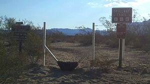
run, hike, bike or gallop by BEEBEE  The Spillway Trail is a wide light trail it runs for 1.15 miles from the south Trailhead located at Signal Butte and McClellan Road to its north end, where it intersects with the Meridian Trail. The following description is from south to north. The trail itself connects with Signal Wash, Levee, Channel, Ruidoso Trails, and Meridian. The trail is an excellent way into the center of the trail system in Usery Mountain Park. The route helps avoid the more crowded trailhead located in the main park area and the other popular ones. The Spillway Trail is a wide light trail it runs for 1.15 miles from the south Trailhead located at Signal Butte and McClellan Road to its north end, where it intersects with the Meridian Trail. The following description is from south to north. The trail itself connects with Signal Wash, Levee, Channel, Ruidoso Trails, and Meridian. The trail is an excellent way into the center of the trail system in Usery Mountain Park. The route helps avoid the more crowded trailhead located in the main park area and the other popular ones.The trail itself on the southern end is flat and sandy with little to no shade. As you go north from the southern trailhead will first pass the Signal Wash trail at its southern end and then again at its northern end. As you approach the southern bank of the Levee at the top of the Levee, you intersect with the Levee Trail. You will notice signs asking you to please use the ramps as the traffic erodes the Levee walls.
Note: This trail gets lots of Mountain Bike and Equestrian activity, so the trail can be rutted and also lots of road apples watch where you step.
Check out the Official Route and Triplogs. Leave No Trace and +Add a Triplog after your hike to support this local community. One-Way Notice This hike is listed as One-Way. When hiking several trails on a single "hike", log it with a generic name that describes the hike. Then link the trails traveled, check out the example. | |||||||||||||||||||||||||||||||||||||||||||||||||||||||||||||||||||||||||||||||||||||||||||||||||||||||||||||||||||||||||||||||||||||||||||||||||||||||||||||||||||||||||||||||||


