Route Editor

| Guide | ♦ | 10 Triplogs | 0 Topics |
details | drive | permit | forecast | 🔥 route |
stats |
photos | triplogs | topics | location |
| 203 | 10 | 0 |
Canyons are inherently risky. Flash floods occur without notice on sunny days. Technical skills & surrounding topography knowledge required yet does not eliminate risk.
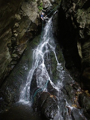
Cascaderific by nonot  Overview OverviewA technical canyoneering trip on Mt Graham. Warning This trip requires technical gear, including: helmet, harness, rappelling device, locking biner, wetsuit (shorty for summer, more otherwise), and 2x200 ft ropes (substituting 1 200 ft rope for a 200 ft pull cord is possible (though not recommended) only if your party is 3 or fewer.) You should also have shoes with a good grip. This is not a canyon for beginners, there are rappels with somewhat awkward starts.
History Described in Todd Martin's book Arizona: Technical Canyoneering. Hike From the Ash Creek Trailhead, descend Ash Creek Trail #307. At the boiler, continue north on Ash Creek Trail rather than heading west towards Webb Peak. As you descend at a moderate grade you will reach a fairly indistinct junction where only one way is marked with a "Trail" sign, indicating left. This is the marker for Ash Creek Trail Bypass #307. Instead, head right (against what the sign says) to stay on the Ash Creek Trail. It gets a little overgrown in a few places. There are metal gratings holding back erosion in places, though it is degrading. Watch your step as you will hop down boulders until you come to a large cascade known as the "Slickrock". Ash Creek here cascades down about 100 ft or so on very slippery rock. This is where you will leave the trail. Downclimb the cascade (be very careful - it is extremely slippery - even stealth rubber is insufficient in places - crabwalk as needed.) It is very scenic and beautiful. From here, the going gets difficult as it is an all-out bushwhack until you reach the top of the first rappel where the creek drops out of sight. Gear up here (wetsuits optional for this first rappel) and rig for a full 170 ft descent, down a slightly angled face. This rappel is very nice and has a nice staging area at the bottom to collect your wits. You will need wetsuits by the next rappel, so might as well put them on about now. Downclimb a bit and do a little more rock hopping to get to the next rappel. The creek here narrows into a tight slot. The next 3 raps come in rapid succession - rope management and staging your party will pay off here with time saved. Generally, no more than 2-3 people can fit at each rap station. The water will chill you off and you are out of the sun for a while, it is fantastic for a hot AZ summer day! The slot angles slightly and it will be awkward trying to deal with the tilt on rappel without being able to extend yourself due to the constriction of the canyon. R2: 50 ft from a boulder - try to go over the edge of the boulder (right LDC) to position yourself out of the main flow. Awkward start. R3: You are dropped above what appears to be a hole bored through the canyon - likely the result of a large chockstone. It is about 90 ft from two rock chocks on right LDC. R4: An awkward rappel around the corner of about 65 ft from a rock chock into a largish pool where the canyon opens up again. After getting your party down, you will be faced with a short distance to walk to rap 5, as the canyon opens up even more and sunlight filters down through the trees. This is about a 90 ft rappel from a large slung boulder. The slope is more moderate, but still extremely slippery as you rappel down the gorgeous cascade. After this rappel, you will be faced with a moderate downclimb of about 70 ft. Having done this (no rappel is rigged) it is certainly possible, though I did not enjoy it. (Not for technical difficulty, but just for the nastiness of it and dealing with the fallen trees) A large tree at the top would seem to make for a perfect anchor to rappel this cascade and be much more enjoyable. Anyways... You will arrive at the top of the last rappel, which consists of a larger drop from the dry side of a cascade and a smaller drop that continues in the middle of the falls (the wettest part of the whole trip) combined to form about 130 ft in total. Watch that your ropes do not get snagged along the way. After this, pack up your gear and begin to rock hop downcanyon. I exited the creek itself to hike along the sides on game trails. Looking to your left (downcanyon) you will soon find a good game trail that leads into Ash Creek Trail. Head up the Ash Creek trail - it is very steep at first and will run into a signpost (devoid of one trail sign) at the intersection with what's left of the upper part of Shingle Mill Trail #35. Head left/south as the Ash Creek trail maintains a more reasonable grade until you reach another trail junction. As before, the only trail signed is the Ash Creek Trail Bypass #307A. You can take this (right) or continue left back onto Ash Creek, which is more scenic and leads you by the Slickrock cascade area you began your canyoneering. Both will rejoin again at the junction you passed on the way in. Return up the trail back to the trailhead. Water Sources Ash Creek runs year-round. Camping Numerous paysites on the top of Mt Graham. Check out the Official Route and Triplogs. Leave No Trace and +Add a Triplog after your canyon trip to support this local community. | ||||||||||||||||||||||||||||||||||||||||||||||||||||||||||||||||||||||||||||||||||||||||||||||||||||||||||||||||