The Thunderbird Recreation Area located along Pinnacle Peak west of 55th Avenue is named after a WWII Fighter training facility that used to be located 4 miles south of the park. Its trails wander up and around Hedgepeth Hills, named for the former Hedgepeth ranch at the site.
H2, or on newer maps, the Arrowhead Trail, ascends the 1862' southeastern peak of the Hedgepeth range. It is most easily accessed via the H1 or Whip Trail from the eastern parking lot and trailhead located at 55th Avenue and Pinnacle Peak. By using this access, one can make a loop that adds .82 miles to the 1.4 mile H2.
Starting at the trailhead, take H1 across a sparse creosote flat leading to H2 proper. From there, switchbacks wander up the slope in a clockwise direction, reaching a plateau at 0.6 miles (15 minutes). The trail stays flat as it heads west toward a notch at 0.75 mi(19 min) that use to frame an enormous Saguaro, whose exploded remains now remain (lightning?). From there, the trail winds up to the main summit at 0.9 mi. (22 min), where a flag sits atop a large summit cairn. It even had solar-powered up lighting at one point, which is rare but correct flag etiquette. (The American flag should not be flown in darkness)
From the summit, the trail follows a ridge west to a lesser summit at 1 mi(26 min) that has a great slant back seat with lovely views of the western half of Thunderbird Park. At that point, the trail heads down to the saddle between the two eastern peaks of the park, reaching a set of Ramadas at 1.4 mi(34 min). This is where H2/Arrowhead ends, but H1/Whip continues east another 0.6 mi(11 min)to your starting point. Total loop 2.2 mi(45 minutes). The most rugged of the Thunderbird Park trails, this trail has typical Sonoran Flora, including Saguaro, Barrel, Cholla, and Buckhorn Cholla, along with Paloverde, Creosote, Brittlebush, and Perennials depending on rainfall. I've seen several Coyotes over the years, as well as some friendly lizards, but only 1 Rattler in over 100 visits. The geology is volcanic tuft, I think, as are most of the peaks in this area.
When hiking several trails on a single "hike", log it with a generic name that describes the hike. Then link the trails traveled, check out the example.
WARNING! Hiking and outdoor related sports can be dangerous. Be responsible and prepare for the trip. Study the area you are entering and plan accordingly. Dress for the current and unexpected weather changes. Take plenty of water. Never go alone. Make an itinerary with your plan(s), route(s), destination(s) and expected return time. Give your itinerary to trusted family and/or friends.
Permit $$
None
Directions
Road
Paved - Car Okay
To hike The eastern parking lot for Thunderbird Park is located in north-central Phoenix, just southeast of 55th Avenue on the south side of Pinnacle Peak Road. The park is open from sunrise till sunset, with gates that are sometimes locked at night.
page created by joebartels on May 27 2013 12:02 pm
 Route Editor

 The Thunderbird Recreation Area located along Pinnacle Peak west of 55th Avenue is named after a WWII Fighter training facility that used to be located 4 miles south of the park. Its trails wander up and around Hedgepeth Hills, named for the former Hedgepeth ranch at the site.
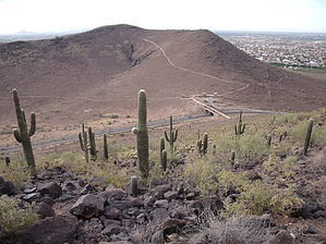


