 Route Editor

| Guide | ♦ | 15 Triplogs | 1 Topic |
details | drive | permit | forecast | 🔥 route |
stats |
photos | triplogs | topic | location |
| 0 | 15 | 1 |
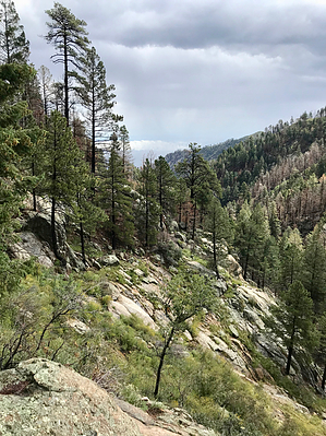
Bypass the fun by nonot  Overview OverviewBypass trail that goes around the roughest parts of Ash Creek Trail #307. Located on Mt Graham. History The Ash Creek Trail #307 gets a little rough - it has some metal gratings holding back erosion, some overgrowth, and boulder hopping. Originally constructed as a horse bypass trail, the forest service now recommends #307A bypass trail of passage for hikers as well. They signed it as the only trail, though this is not true.
As you hike down along the Ash Creek Trail from the trailhead just off Swift Rd, you will first come to a junction at a boiler with the Webb Peak trail, and relatively shortly after this, you will arrive at a trail junction where a carsonite trail sign directs you left, climbing away from the creek. Although unsigned this is the beginning of the Ash Creek Trail #307A Bypass trail. This trail is better for horses and those that cannot do rock scrambling but is far less scenic than the trail that follows the creek. The trail climbs partially up the hill where it will level off and proceed higher along the ridge above the creek. I imagine this will give a great vantage point in the fall for capturing the changing colors of the Aspen. The trail crests the hill and proceeds down the other side, making a few short switchbacks as it rejoins the Ash Creek Trail #307. From here, if you bypassed the Ash creek trail, I would recommend the hiker proceed right (back up the Ash Creek Trail #307) for about 300 ft until you arrive at the slickrock cascade area, which is quite beautiful at all times of the year. The going here is very easy with only a slight uphill section to hike. Water Sources Ash Creek flows throughout the year, hikers may choose to make a loop of this with the Ash Creek trail itself to vary their hike out. Camping The junction with the boiler is fairly flat and could likely handle a tent or two. Numerous paysites on the top of the mountain. Check out the Official Route and Triplogs. Leave No Trace and +Add a Triplog after your hike to support this local community. One-Way Notice This hike is listed as One-Way. When hiking several trails on a single "hike", log it with a generic name that describes the hike. Then link the trails traveled, check out the example. | |||||||||||||||||||||||||||||||||||||||||||||||||||||||||||||||||||||||||||||||||||||||||||||||||||||||||||||||||||||||||||||||||||||||||||||||||||||||||||||||||||||||||||||||||||||||||||||||||||||||||||||||


