If you do the loop, I suggest counter-clockwise for better views and a little more forgiving on the knees. Nevertheless, this trail is listed from the #105 since the forest service has given it the spur "A" designation of North Mingus Trail #105.
Regardless of how you get to the trail, it's pretty easy in either direction. The views are incredible throughout. Most notably is the birds-eye view of Cottonwood just under 5 miles to the northeast. Looking straight past Cottonwood you should get a decent view of Cathedral Rock in Sedona too!
The healthy Gambel Oaks seem to be the main attraction along this trail. They add the golden blaze early to mid-October foliage season. It's short-lived at maybe a week in prime; tops. If you are lucky enough to tag along with this guy he might lend you some advice on how to make your photos sing.
When hiking several trails on a single "hike", log it with a generic name that describes the hike. Then link the trails traveled, check out the example.
WARNING! Hiking and outdoor related sports can be dangerous. Be responsible and prepare for the trip. Study the area you are entering and plan accordingly. Dress for the current and unexpected weather changes. Take plenty of water. Never go alone. Make an itinerary with your plan(s), route(s), destination(s) and expected return time. Give your itinerary to trusted family and/or friends.
 Route Editor


 Overview
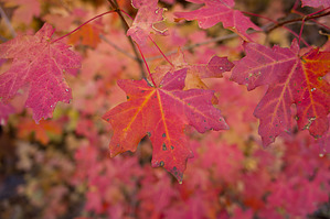


