 Route Editor

| Guide | ♦ | 9 Triplogs | 1 Topic |
details | drive | permit | forecast | 🔥 route |
stats |
photos | triplogs | topic | location |
| 77 | 9 | 1 |
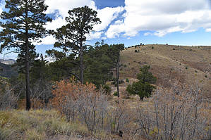
Trail to middle of nowhere by markthurman53   Overview OverviewThe Bootlegger Trail's eastern trailhead is along the Crest Trail, 0.4 miles south of the Rustler Park junction with the Crest Trail. This trail heads down a ridge that separates the Pine Canyon/Rattlesnake Canyon from the Rock Creek drainage systems and terminates at Rattle Rock Saddle at the Rattlesnake Trail and the Witch Ridge Trail (some maps show Rattlerock Saddle as being the Saddle above this junction). The Rock Creek Trail intersects the Bootlegger trail about 0.8 miles down from the upper Bootlegger Trail Head just above Rock Saddle and parallels it for about 0.1 miles to Rock Saddle. At this upper intersection, the Rock Creek Trail exits to the southeast and heads up to the Crest Trail at Bootlegger Saddle. At Rock Saddle the Rock Creek Trail comes in from the south from Rock Creek. The Bootlegger Trail is in fair condition but can be hard to locate in some sections due to burns in 1994 and 2011. Rock cairns mark the trail most of the way. A GPS Route is also handy. The easiest access to this trail is from Rustler Park along the crest of the Chiricahua Mountains. From the west, this trail can be accessed via Turkey Canyon or Pine Canyon but not directly. Description From the Crest Trail, the bootlegger Trail heads west climbing a small ridge for the first 100 yards. From this ridge, there are great views in almost all directions except to the southeast (big hill in the way). The trail trends a southwesterly downhill direction to Rock Saddle. This area was burned pretty badly twice, the first time killing the trees the second time cleaning out all the deadfall, so the trail can be a bit faint at times. At least you don’t have to search for the trail while climbing over logs. There are two separate sections of switchbacks and in these areas, you want to watch for when the trail makes a sudden turn. I found these were marked with cairns but in the summer when the ferns are growing they might be hard to see. The GPS is the best protection from this.
This is a good trail if you are looking for views. All of Southeast Arizona is within view. Dos Cabezas, Pinaleno’s, Catalina Mountains, Rincon Mountains, A bit of Santa Rita Mountains, Dragoons and Huachuca Mountains. Also a few I forgot to mention and a couple of minor ranges. Closer in are views of both Pine Canyon and Rock Canyon. Since this trail ends in the middle of nowhere, this trail is typically not a destination trail but instead used as a connecting trail as part of a means to an end, such as Pine Canyon to Rustler Park, or Part of a loop trail with maybe Rock Creek. Coronado FS Details Bootlegger Trail is a short, steep side trail off the Crest Trail #270 in the vicinity of Rustler Park. It connects the Crest with two primitive forest trails, Rattlesnake Trail #275 and Rock Creek Trail #259, both of which lead down the mountain to the west. The Bootlegger Trail connects with the Crest at two points. One is just above Rustler Park Campground about 0.4 mile south of where the access trail from the campground intersects the Crest. The other junction is at Bootlegger Saddle, about one trail mile farther south on the Crest. In between those two points, the Bootlegger Trail drops down onto a saddle that separates the upper reaches of Rattlesnake and Rock canyons. Trail surroundings here are forests of pine and fir. The saddle and a few points along the trail offer views of both of the aforementioned drainages as well as the lower western slopes and peaks of the Chiricahuas. The southern section of the trail, between the Rattlesnake/Rock Creek junction and Bootlegger Saddle is very steep, ascending 500 feet in less than half a mile. The northern section of the trail has some stretches that will make you breathe hard as well. In addition to providing access to the Rattlesnake and Rock Creek Trails, Bootlegger Trail offers an opportunity for a loop out of Rustler Park Campground. This loop incorporates about a mile and a half of the Crest Trail from the campground. Best views are at Bootlegger Saddle where you can see a number of mountain ranges and valleys to the west and south of the Chiricahuas. Check out the Official Route and Triplogs. Leave No Trace and +Add a Triplog after your hike to support this local community. One-Way Notice This hike is listed as One-Way. When hiking several trails on a single "hike", log it with a generic name that describes the hike. Then link the trails traveled, check out the example. | ||||||||||||||||||||||||||||||||||||||||||||||||||||||||||||||||||||||||||||||||||||||||||||||||||||||||||||||||||||||||||||||||||||||||||||||||||||||||||||||||||||||||||||||||||||||||


