| Guide | ♦ | 2 Triplogs | 0 Topics |
details | drive | permit | forecast | map |
stats |
photos | triplogs | topics | location |
| 0 | 2 | 0 |
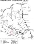
Hike with future Citizens by HAZ_Hikebot  A little-used pathway (at least by documented citizens) called the Border Trail. This foot and horse path was put here to provide access for maintenance of the international boundary fence. It leads over the grassy foothills of the Pajaritos to the end of the Summit Motorway (FR 39A), which may sound like a thoroughfare, but it's a 4-wheel drive road. A little-used pathway (at least by documented citizens) called the Border Trail. This foot and horse path was put here to provide access for maintenance of the international boundary fence. It leads over the grassy foothills of the Pajaritos to the end of the Summit Motorway (FR 39A), which may sound like a thoroughfare, but it's a 4-wheel drive road.Technically you can use this as an exit from Sycamore Canyon Trail #40, but nobody in their right mind would do so.
Check out the Triplogs. Leave No Trace and +Add a Triplog after your hike to support this local community. One-Way Notice This hike is listed as One-Way. When hiking several trails on a single "hike", log it with a generic name that describes the hike. Then link the trails traveled, check out the example. | ||||||||||||||||||||||||||||||||||||||||||||||||||||||||||||||||||||||||||||||||
 Route Editor


