Route Editor

| Guide | ♦ | 8 Triplogs | 0 Topics |
details | drive | no permit | forecast | 🔥 route |
stats |
photos | triplogs | topics | location |
| 180 | 8 | 0 |
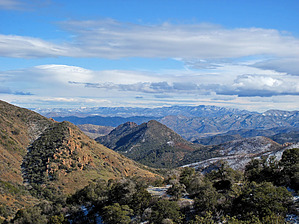
.. Thoroughly All Inclusive .. by Grasshopper   Overview OverviewWith planned stops, this full-day driving loop which travels along or near the boundary of the eastern Superstition Wilderness passes by thirteen (13) hiking trailheads and begins and ends east of Florence Junction at the intersection of Highway 60 and Queen Valley Road. This scenic and historic four-wheel drive/high clearance route begins at an elevation "low" of 1982 feet and travels to an elevation "high" of 5394 feet with only 1.6 miles of the total 48.6 miles on a paved surface via Queen Valley Road. Warning This multi-forest road loop route travels on many varied road conditions depending on the time of year and seasonal road maintenance. For safety reasons this 48.6-mile loop route should only be considered with an experienced off-road driver who is driving a 4WD, high clearance vehicle with upgraded LT-type rated tires. Also, in order to locate the many hiking trailhead locations along this route as well as to correctly navigate the many forest road turns along this driving route, it is highly recommended that the "official" GPS Driving Route dated 12/23/11 (posted to this description) along with its twenty-one (21) reference waypoints be downloaded and followed. Obviously, planned driving route stops are optional but understanding and being able to correctly navigate this driving route is important.
This scenic driving loop passes by old ranching homesteads- some still operational and considered private property as posted. One of the more interesting late 1800's mining/ranching homesteads available to visit and included in this driving loop GPS Route tour is the Wood Camp Cabin site located on a short unmarked 4WD access road off of FR650. It is highly recommended to plan a stop here to view the interesting and still standing (as of this writing) old stone cabin. Then a short walk down to the Wood Camp Canyon Creek bed area to see the old water well location along with a deep mining shaft (adit) which is located across the creek bed. Drive Follow the "official" 12/23/11 posted GPS Route. This 48.6-mile driving route, recommended to be driven in a "clockwise" loop direction, covers many scenic square miles within the Tonto National Forest - eastern Superstition Wilderness area including varied desert flora and geology. From author's 12/23/11 trip log: I had often thought that this scenic eastern Superstition Wilderness 4WD loop trip would make an excellent day outing for family and/or out of state visitors who are not into hiking but would rather enjoy a longer back-country day driving trip with varied flora, geology, amAZing near and long-distance views, and with ranching/mining history. I am now happy to report that for the right situation it would! I would highly recommend those more adventurous with a good, stock, high clearance 4WD vehicle with LT-type rated tires to strongly consider this one. It's a winner! Check out the Official Route and Triplogs. Leave No Trace and +Add a Triplog after your 4x4 trip to support this local community. | ||||||||||||||||||||||||||||||||||||||||||||||||||||||||||||||||||||||||||||||||||||||||||||||||||||||||||||||||||||