Route Editor

| Guide | ♦ | 65 Triplogs | 1 Topic |
details | drive | no permit | forecast | route |
stats |
photos | triplogs | topic | location |
| 878 | 65 | 1 |
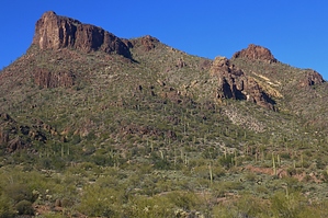
Burro Into The Hieroglyphics by AZWanderingBear  Overview OverviewThe hike takes you up to the predominant peak to the North West of the Walkin' Jim Trail. This hike is an extension of the Walking Jim Trail. Eventually, the trail gives way to some strategically placed cairns leading up to the peak. The summit offers spectacular views of Lake Pleasant, the Hieroglyphic Mountains, Hells Canyon, and the Bradshaw Mountains to the north. Don't be surprised to see wild burros, descendants of animals used by local miners and ranchers, along the trail or to hear the echoes of their braying bouncing through the canyons below you. Warning The upper reaches of this hike involve loose rocks, some exposure, and a bit of rock scrambling. Route finding can be challenging as you near the upper portions of the hike. As always, be aware of the poking, stinging, and biting flora and fauna of the Sonoran Desert.
The trailhead on the western side of Castle Hot Springs Road has ample parking. It is used as a jumping-off point for ATV riders, so expect to see some trucks and trailers in the parking lot. Your hike begins at a cut in the fence on the northwest corner of the parking lot. The first portion of the hike follows the northern side of the Walkin' Jim Trail. You will drop down into a shady portion of Cottonwood Creek. This part of the creek often has small pools of water. The trail continues across and out of the creek bed. Looking west you can't help but admire the imposing profile of 3465. Continue to follow the well-worn Walkin' Jim Trail for approximately 3.9 miles to the well-signed intersection of the Big Jim Trail. The Big Jim is fairly easy to follow. A few well-placed cairns will generally keep you on track, but beware of well-worn burro trails that wind haphazardly through this entire area. The trail crosses a few minor drainages before working its way up a fairly large wash. You will be tempted to think that the route continues up this drainage. It doesn't. As you get higher up you will understand why. The trail abruptly crosses the wash and turns southeast, almost directly away from your objective. The trail crosses a small ridge and again turns north paralleling another drainage. The trail here is rocky and loose, probably the most demanding section of the entire hike. To your right is a steep drop into the wash with a lichen-covered rock wall on the other side. Luckily this rough section is short-lived and you will soon top out on a small and scenic saddle a great place for a short break before the final push to the summit. Beyond the saddle, the trail fades considerably. Initially, you will climb WSW. Keep your eye peeled for small cairns. The route takes you around the north side of the large rock outcropping straight ahead. No rock climbing is required. Stay parallel to the northern side of the outcropping and you emerge at another small saddle. Cross this and ascend the small slope straight ahead. Soon you will see an area of terraces sloping upward to the south. My path took me to the northern end of the highest terrace and then south along the terrace to a very obvious notch in the caprock. Climbing up the notch to the summit plateau is accomplished easily enough. Remember where you topped out for the return trip. The summit views are fantastic. With good visibility, much of central Arizona is at your feet. The view of Lake Pleasant is superb. Directly below you to the northwest are Burro Flats and Burro Spring. The rugged Hieroglyphics span your western view while the Bradshaws tower to the north. On a clear day, you can spend an hour checking off landmarks. When it's time to leave, retrace your steps back to the intersection of the Big Jim and Walkin' Jim. To add a bit of variety and miles, complete the Walkin' Jim Loop. Or if you are in a hurry, just stick with the way you came in. Hopefully, you will see some burros. Fox, deer, and coyotes are abundant in this area also. Enjoy. Check out the Official Route and Triplogs. Leave No Trace and +Add a Triplog after your hike to support this local community. | ||||||||||||||||||||||||||||||||||||||||||||||||||||||||||||||||||||||||||||||||||||||||||||||||||||||||||||||||||||||||||||||||||||||||||||||||||||||||||||||||||||||||||||||||||||