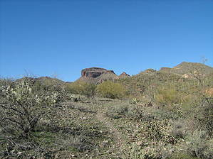
Bees buzzing in cottonwoods and the screams of redtail hawks will greet hikers in the spring along this trail, but keep your eyes and ears peeled for diamondback rattlesnakes. Though drought has had a major impact on the wildlife you may still encounter javelina, deer, Gila Monster, skunk, Harris Antelope Squirrel, collared lizard, feral burro, and a variety of birds. Ocotillo burst into life after a summer rain, and barrel cactus have a healthy reddish glow. The Hieroglyphic Mountains loom on the near horizon as you wend your way through a variety of classic Sonoran desert terrain.
From the trailhead, hike west along a well-worn path and cross over Cottonwood Creek (CC). Follow the trail up the embankment and onto a plateau. Shortly the trail forks - bear right to follow the main trail or bear left and take a scenic side trip(see below). Either way, you'll end up on the same trail heading west toward the Hells Canyon Wilderness. After bearing right at the fork hike past ancient mesquite trees until the trail meets up with the side trip trail - then bear right(west). From this point follow a single track west crossing numerous washes along the way. At about 2.5 miles cross a little-used ranch road and enter the Hells Canyon Wilderness. The trail will take you very close to the base of the high peak which dominates the western horizon - a great opportunity for peak baggers.
This trail winds its way up, down, and all around on its way to God's country so you'll have to pay attention while hiking it. My grandson calls it the zigzag trail, but there is a tread most of the way, and where it fades, cairns mark the way.
The scenic side trip trail - bear left at the fork and cross over CC wash. As you head west along the south side of CC wash search for Indian rock art on your right. A large boulder with a geometric design can be seen from the trail, but other petroglyphs, including very faint bighorn sheep figures, must be searched for. Pass by a grove of cottonwoods and a small frog pond then look across CC wash and see the trail climbing up a redrock embankment. Stay on this trail. The main trail will intersect it within 200 yards.
WARNING! Hiking and outdoor related sports can be dangerous. Be responsible and prepare for the trip. Study the area you are entering and plan accordingly. Dress for the current and unexpected weather changes. Take plenty of water. Never go alone. Make an itinerary with your plan(s), route(s), destination(s) and expected return time. Give your itinerary to trusted family and/or friends.
Permit $$
None
Directions
Road
Paved - Car Okay
To hike From Phoenix, take I-17 north to the Carefree Highway (SR 74). Turn left on Carefree highway and drive west to Castle Hot Springs Rd (Lake Pleasant exit). Turn north and drive for approximately 5 miles to a large pull-off on the left side of the road. Careful of deep sand in the parking area. The hike begins at the northwest corner of the parking lot on the other side of a fallen barbed-wire fence.
 Route Editor


 Bees buzzing in cottonwoods and the screams of redtail hawks will greet hikers in the spring along this trail, but keep your eyes and ears peeled for diamondback rattlesnakes. Though drought has had a major impact on the wildlife you may still encounter javelina, deer, Gila Monster, skunk, Harris Antelope Squirrel, collared lizard, feral burro, and a variety of birds. Ocotillo burst into life after a summer rain, and barrel cactus have a healthy reddish glow. The Hieroglyphic Mountains loom on the near horizon as you wend your way through a variety of classic Sonoran desert terrain.