 Route Editor

| Guide | ♦ | 15 Triplogs | 0 Topics |
details | drive | permit | forecast | route |
stats |
photos | triplogs | topics | location |
| 115 | 15 | 0 |
  Overview OverviewSheepshead Peak is a two-part hike in the western Dragoon Mountains in Coronado National Forest. Part One is an easy hike over gently rolling hills covered in swaying grasses. Then, just as you're getting all comfy and complacent, the climb begins, first over sketchy granite terrain and then up a "use all four" chute to Sheepshead Peak. Warning Gloves recommended for the scramble. If they make you feel more comfortable on loose terrain, hiking poles could come in handy.
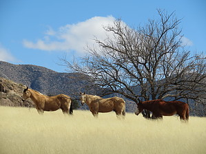
From the parking area just past the Tenneco Well, find the gate to the northeast. Pass through the gate, and you're instantly on a well-worn path headed due north. The trail gradually ascends and winds its way along a hillside on the right. Along the way, you might imagine you're in the Serengeti as your fingertips brush the tops of waving, golden grasses. Ahead you spot zebras grazing (okay, so they're horses), African buffalo (well, just cattle), gazelles (all right, all right, they're deer), a small lion slinking past (bobcat), and exotic blackbirds cawing (noisy crows). I jest, but the surroundings make you think of the "Mutual of Omaha" TV show. The path drops down into a small wash, heading a bit east and continuing through the grasses in a northeast direction. You'll come to a wooden/wire gate. Pass through, and you're in an entirely different world. The trail is now more wooded, and quite quickly, the terrain changes to that of rocky granite. All the while, you're wondering, "which peak is Sheepshead?". Peering up to your right, you spot, far above you, little, itty-bitty rock climbers on a massive yellowish rock slab. That can't possibly be Sheepshead. I thought this was a hike, not a climb! Your GPS or map, though, tells you that, most likely, it is Sheepshead. So, follow the map and see where it takes you. The trail becomes somewhat of a scramble and is lightly cairned. Note that there are several social trails, probably created by those crazy climbers, but your goal is to stay close to that massive slab. After some moderate scrambling, the trail becomes rather steep (and shaded), and the use of both hands and feet is nearly mandatory. We thanked many a tree for offering handholds on the way up. You will skirt the base of Sheepsheads’ cliffs and begin climbing a rocky chute of sorts toward your first destination: a notch or saddle on the northwest side of Sheepshead. This saddle offers a place to rest and see deep into the Dragoons to the east. Once you have reached the saddle, the lightly cairned route or social trail that you have followed to this point continues, and is the most straightforward route to the summit. Make a hard right at the saddle to begin the ascent of Sheepshead’s northwest face. This is the route that I found to be the easiest, safest, and most enjoyable. You will need to use hands and feet to scramble up the rock in many places, but nothing is dangerous. Be sure to take note of your ascent route and surroundings, so you do not become confused or “cliff out” on your descent. As much of the final ascent is on bare rock, you will need to route-find in places and pick your way through the pinyon pines, rock slabs, and boulders. As you climb, the view to the east of the Dragoon Mountains’ interior, with its impossible maze of granite boulders and crevices, is incredible. Nearing the top, the route turns south. Scramble up the summit block and make your way to the highest point on Sheepshead’s bare, rocky dome for an unforgettable 360-degree view. There is plenty of room among the granite bedrock and potholed slabs to stretch out and enjoy your surroundings. Returning via your ascent route is highly recommended, as non-technical descent routes are limited. Watch your footing, be safe, and enjoy. Water Sources A stream at the base of Sheepshead was running when we were there, but there had been recent rains, so we're not sure if it is a constant water source. The maps reveal no springs near the peak. Gate Policy: If a gate is closed upon arrival, leave it closed after you go through. If it is open, leave it open. Leaving a closed gate open may put cattle in danger. Closing an open gate may cut them off from water. Please be respectful, leave gates as found. The exception is signage on the gate directing you otherwise. Check out the Official Route and Triplogs. Leave No Trace and +Add a Triplog after your hike to support this local community. One-Way Notice This hike is listed as One-Way. When hiking several trails on a single "hike", log it with a generic name that describes the hike. Then link the trails traveled, check out the example. | |||||||||||||||||||||||||||||||||||||||||||||||||||||||||||||||||||||||||||||||||||||||||||||||||


