Road to Nowhere - FR 861, AZ | HikeArizona
   🔥

Road to Nowhere - FR 861, AZ

Guide 48 Triplogs Mine 0 0 Topics
 
3.5 of 5 
Fav
Wish
0
details
drive
permit
forecast
🔥
route  
stats
photos
triplogs
topics
location
89 48 0
Statistics
tap icons for details
Difficulty 2.5 of 5
Route Finding 1 of 5
Distance Round Trip 4.6 miles
Trailhead Elevation 4,695 feet
Elevation Gain 800 feet
Avg Time Round Trip 2-3 hours
Kokopelli Seeds 8.6
unreported if dogs are allowed
editedit > ops > dogs to adjust
feature photo
Photos Viewed All MineFollowing
2  2019-09-09 fricknaley
15  2018-06-28 SkyIslander18
15  2017-01-17 SkyIslander18
1  2016-09-14 fricknaley
14  2014-01-23 SkyIslander18
8  2013-08-28 PrestonSands
7  2013-08-28 SkyIslander18
4  2013-05-14 SkyIslander18
Page 1,  2
Author
author avatar Guides 3
Routes 0
Photos 4,732
Trips 2,247 map ( 10,634 miles )
Age 53 Male Gender
Location Small Town USA
Associated Areas
list map done
Tucson Region
Historical Weather
Trailhead Forecast
Radar Map
Expand Map
Sun  6:28am - 6:28pm
Official Route
 
0 Alternative
 
 Water
Historic Fire Perimetersacres
🔥 2017 Frye Fire48.4k
🔥 2004 Nuttall30k
🔥 View (All) - over Official Route 🔥
Nearby Area Water
[ View More! ]
Fauna  Nearby
Flora  Nearby
Named place  Nearby
no photo labels yet
+Add > Photos to this Guide
then label as applicable
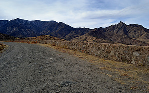
over the rainbow
by SkyIslander18

Overview
Known locally as the Road to Nowhere, Forest Road 861 was started in the early 70's using prison labor and was to be a "new" road up to the top of the Graham mountains (Pinalenos). The project stalled when funding ran out and the road was never completed.
Hike
The first 2 miles can be driven, but is much more enjoyable & scenic to hike with many outstanding overlooks down onto the Gila valley below along the way. The last 0.3 miles must be hiked as it rounds the mountain.

Check out the Official Route and Triplogs.

Leave No Trace and +Add a Triplog after your hike to support this local community.

2018-02-01 SkyIslander18
    WARNING! Hiking and outdoor related sports can be dangerous. Be responsible and prepare for the trip. Study the area you are entering and plan accordingly. Dress for the current and unexpected weather changes. Take plenty of water. Never go alone. Make an itinerary with your plan(s), route(s), destination(s) and expected return time. Give your itinerary to trusted family and/or friends.

     Permit $$
    None

    Coronado Forest
    MVUMs are rarely necessary to review unless mentioned in the description or directions
    Coronado Motor Vehicle Use Maps (MVUMs)


     Directions
    or
    or
     Road
    FR / Jeep Road - Car possible when dry

    To hike
    From Safford, head south on U.S. highway 191. Turn west onto state highway 366 (Swift Trail). Follow highway 366 for 5.8 miles and turn right onto Forest Road 861. Take FR 861 for .3 miles to large parking area on the right.
    page created by SkyIslander18 on Mar 01 2012 8:31 am
    helpcorrectionissue

    end of page marker