username
X
password
register
for free!
help


Valley View Trail #1E, AZ

Guide 15 Triplogs  0 Topics
  2.3 of 5  
Fav
Wish
0
details
drive
no permit
forecast
route  
stats
photos
triplogs
topics
location
32 15 0
Statistics
tap row or icons for details
Difficulty 0.5 of 5
Distance One Way 0.17 miles
Trailhead Elevation 1,580 feet
Elevation Gain -70 feet
Avg Time One Way 5 min
Kokopelli Seeds 0.29
feature photo
Photos Viewed All MineFollowing
Inaugural Calculation on Button Tap!
5  2025-04-26 mt98dew
9  2020-03-31
Freedom - Valley View - Basin Tr - Irregular
joebartels
18  2020-03-01
Phx Preserves Irregular Circumference
joebartels
Author
author avatar Guides 264
Routes 2,797
Photos 14,494
Trips 5,894 map ( 29,783 miles )
Age 55 Male Gender
Location
Associated Areas
list map done
Phoenix Region
Historical Weather
Trailhead Forecast
Radar Map
Expand Map
Preferred Feb, Jan, Dec, Nov
Sun  6:05am - 6:48pm
Official Route
 
3 Alternative


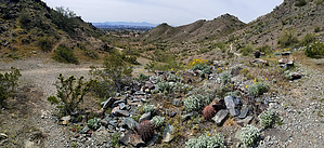
900 ft Basin Alternative
by joebartels

 
Note
Like the popular Dixie Peak 2,429, this is not a signed trail. If the trail is signed area closed, do NOT enter.


From the West
#1E is the first trail that turns off Perl Charles Trail #1A on the north side of Myrtle Creek. Since Valley View Trail #1E is not signed, it's good to have a route on hand. Tread is like a firm gravel road. It travels well and is well defined.
remove free decal offer
Halfway up, it crosses a ravine with a couple of Palo Verde trees that offer a hint of shade if you need to pause. Turn around, and the name of this trail becomes crystal clear. Downtown Phoenix Arizona with a background of South Mountain tapering down in front of the Sierra Estrella Mountain Range.

Near the east end of the trail at a little saddle, yards north looks like something old has returned to rubble. Just a pile of rocks, nothing exciting.

5-10 yards east of the saddle is the unsigned junction with Basin Trail #1D.

Synopsis
Life moves pretty quick, don't let this little slice of heaven escape your hiking portfolio.

2020-04-01 joebartels


    Check out the Official Route and Triplogs.
    Leave No Trace and +Add a Triplog after your hike to support this local community.

    One-Way Notice
    This hike is listed as One-Way.

    When hiking several trails on a single "hike", log it with a generic name that describes the hike. Then link the trails traveled, check out the example.
    WARNING! Hiking and outdoor related sports can be dangerous. Be responsible and prepare for the trip. Study the area you are entering and plan accordingly. Dress for the current and unexpected weather changes. Take plenty of water. Never go alone. Make an itinerary with your plan(s), route(s), destination(s) and expected return time. Give your itinerary to trusted family and/or friends.

     Permit $$
    None


     Directions
    or
     Road
    Paved - Car Okay

    To hike
    page created by joebartels on Mar 08 2012 2:06 pm
     90+° 8am - 6pm kills
    helpcorrectionissue

    end of page marker