 Route Editor

| Guide | ♦ | 18 Triplogs | 0 Topics |
details | drive | no permit | forecast | map |
stats |
photos | triplogs | topics | location |
| 528 | 18 | 0 |
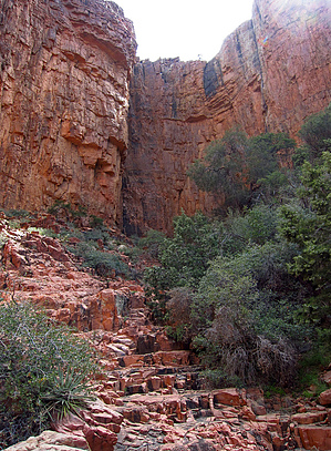
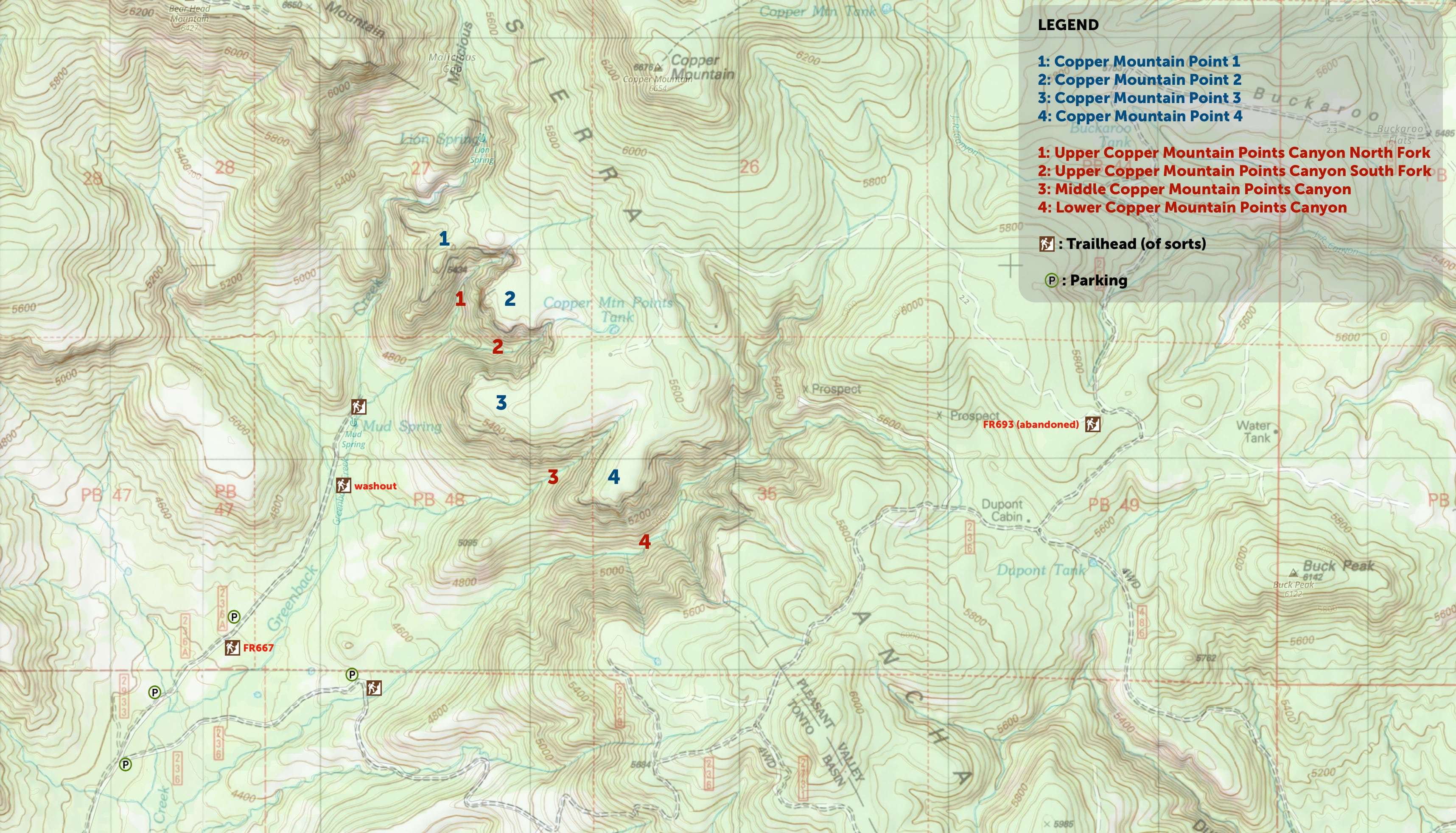
  -- 2012 ssk44 -- Overview Scenic and diverse Sierra Ancha destination with rugged adventurous canyon routes and grand views of Greenback Valley and Bear Head Mountain. This destination as posted is the lower 4x2 access along Greenback Creek off FR236A. Upper access is road hiking along abandoned FR693 off FR236 from Dupont Cabin (see attached map). Upper TH access is strictly 4x4. -- 2022 eru -- Clarification We've come up with standardized names for regions. All of the triplogs here before 2022 have been in the Upper Copper Mountain Points Canyon North Fork, so that's well covered with routes, text, and photos. Ones from this point forward should use the new names to avoid any confusion.
When something is described as "easy", it's with the understanding that someone is extremely comfortable with class 2/3 off-trail micro-navigation, moving on steep loose terrain, boulder hopping, shifting talus, bashing past tree branches or bushes, scrambling, occasional short easy pitches of "climbing" (canyoneering grade 1/2, Yosemite decimal 3/3X), etc and there should be no significant risk, challenge to such a person, or protective/aid gear required. Nothing aside from walking to the points from FR693 is actually easy. :) Also checking Tonto Creek water gauge levels is mandatory until the new bridge comes in. Anything close to ~200cfm would be 4x4 only and depending on the conditions it could be far less than that. A recently graded ford with twice the water is a simpler crossing than one where vehicles lurching around with water above their wheels due to ruts. Watch a few people cross first if in any doubt. So that said... there's a lot of stuff here eh? Let's go over it :) Upper CMP Canyon North Fork: as stated above, many GPX routes and triplogs for this one, so if you want more detail go do your homework. Head up FR236A past the giant wash out, then traverse over some semi-open terrain to the drainage that comes out of the canyon when you hit 3 large pink rocks in the middle of the road. Basically, walk along the creek when it's flat, up it when it's not (lotta rocks), then enjoy the stunning upper section. There's a fairly rough but optional (but worth it IMO) cut out of the creek along the edge of a talus field, bashing into a gully, heading up that to a stable traverse to a nice pillar garden with an easy drop down to the upper slickrock part of the canyon (extra optionally you can cross over a lot more of that talus for a ruin). I'd recommend doing at least the shorter version of it on the way up, then just drop down the creek on the way back. It could also be used to bypass the steep set of cascades at the bottom if there was enough creek flow to impact navigation. GPX routes / triplog guides aren't really necessary aside from doing that little upper detour for the first time, as it's easy to get cliffed out and there's not a great way to describe where to start it. Upper CMP Canyon South Fork: isn't quite as stunning at the top, but still really cool and just as great in a more intimate Indiana Jones kinda way. It's the same as the north fork up to the junction obviously, and if you have time doing both is well worth it. The lower part past the junction is a bit more enjoyable with more slab and views vs endless claustrophobic boulder hopping. The upper cut here isn't as special (and ironically initially gets you the worst bushbashing of the trip) but adds variety. I would strongly recommend scampering up the chunky drainage on the north side of the canyon (you can't miss it) on your way down for some cool views. For further reading, this triplog & associated goodies should spoil the surprise. One thing to note is you can get nearly all the way up without any major obstacles, but there is a relatively straightforward ~15" solid class 3 crux (photos here and here) to upclimb/downclimb if you want to hop up to the canyon's rim (highly recommended). It's a bit more technical than going up the wall of the falls at malicious gap, but it's a fraction of the height. Bring good soles as the rock has been smoothed by water. :| GPS isn't really necessary here, it's all pretty obvious (keep left near the top) though you could miss the chunky side drainage if you stick low both times and were focused on footing. Middle CMP Canyon: works as a connector between the points and Greenback Valley and is non-technical, but is underwhelming in general and has an extended bushwhacky section. It's worth checking out from the top until it gets terrible, but not really coming all the way up the bottom IMO. Go over the triplog & associated goodies to learn more about the canyon we did so you don't have to. Lower CMP Canyon: surprisingly cool, if it was 1/2 mile from a paved road this'd be a popular hike up to the waterfall. As is it's near the bottom of the pack for this area but still well worth seeing. The simplest rock creekbed hiking in the area (though cutting in a bit high on the north and dropping in around 4800ft might be more optimal), nice long open stretches of pools and slickrock cascades, views of pillars and cliffbands on the ridges nearby, and a small if interesting waterfall. Bypassing the waterfall means some loosish class 3 with cactii obstacles, but you're rewarded with a gorgeous area above it. The North Fork starts off amazing and comes and goes between bushwhacking, nice slickrock cascades, and interesting class 3 chonky falls petering out as it gets closer to FR693. Further reading & geocoded photos etc but if you want to do it, it's doable blind and probably more fun. :) The south fork of this was actually LESS bushbashy, but had a bit more (simple Class 3) climbing in it, you also drop out right by DuPont Cabin. If doing it once from the bottom, it might make sense to go up the north fork a bit then drop down and just go up this one. We also found a nice drop that cuts off the worst parts of walking the road back detailed in the triplog. Point 1: can be gained several ways, while the simplest is an easy flat walk from abandoned FR693. From ~Greenback there's an easy walk up from Malicious Gap, and a harder drop down to nearly the trailhead as outlined in this triplog and associated route and geocoded photoset. Other (possibly better options?) into Upper CMP Canyon North Fork are near the saddle dropping into the slickrock near the top and a long diagonal cut lower into the canyon. It's a cool spot, and for an aggressive dayhike, could be used to join Malicious Gap and the Upper CMP Canyon Forks. Points 2, 3, & 4: the simplest approach is an easy flat walk from abandoned but in decent shape FR693. You can also take the scenic exit out of the top of Upper CMP Canyon South Fork between 2 & 3 or head up and out of Middle CMP Canyon which would give you easy access to 3 & 4, though I'd honestly just recommend cutting up the south face of point 3 instead. Our Middle Canyon trip went to some great viewpoints here and found some old mining remnants, but that's just what we stumbled across. Point 4 could be gained/dropped in a few spots.
Check out the Triplogs. Leave No Trace and +Add a Triplog after your hike to support this local community. One-Way Notice This hike is listed as One-Way. When hiking several trails on a single "hike", log it with a generic name that describes the hike. Then link the trails traveled, check out the example. | |||||||||||||||||||||||||||||||||||||||||||||||||||||||||||||||||


