username
X
password
register
for free!
help
 This is likely a great time to hike this trail!  Check out "Preferred" months below, keep in mind this is an estimate.
  

West Divide Trail #289, AZ

Guide 13 Triplogs  1 Topic
  3.8 of 5  
Fav
Wish
0
details
drive
permit
forecast
route  
stats
photos
triplogs
topic
location
0 13 1
Statistics
tap row or icons for details
Difficulty 5 of 5
Distance One Way 24 miles
Trailhead Elevation 4,269 feet
Elevation Gain 2,702 feet
Accumulated Gain 6,837 feet
Kokopelli Seeds 46.78
unreported if dogs are allowed
editedit > ops > dogs to adjust
feature photo
Photos Viewed All MineFollowing
Will recalculate on button tap!
72  2025-03-21
South Galiuro Loop
jacobemerick
24  2025-02-17
Tent Lookout Loop
jacobemerick
71  2024-04-13
West Divide Loop - Galiuro Mountains
jacobemerick
16  2024-04-12
East / West Divide south loop
ShatteredArm
6  2024-03-25
Galiuro Loop
Layne32
28  2015-10-11
Powers Divide S.Field Loop
chumley
29  2015-10-09
Powers Garden
BiFrost
15  2015-03-28
Rattlesnake Trail #285
whereveriroam
Author
author avatar Guides 16,843
Routes 17,472
Photos 24
Trips 1 map ( 6 miles )
Age 28 Male Gender
Location HAZ, TrailDEX
Associated Areas
list map done
Tucson Region
Historical Weather
Trailhead Forecast
Radar Map
Expand Map
Preferred Sep, May, Aug, Jul
Sun  5:58am - 6:42pm
Official Route & 1 Rt
 
5 Alternative


Lovers & Dreamers Bassett-Biscuit Connection
by HAZ_Hikebot

 Likely In-Season!
The Galiuro Mountains grace the southeast Arizona landscape as a pair of ridges split by a north/south canyon complex.


Two main ridges enclose this canyon duet made up of Rattlesnake Canyon flowing north and Redfield Canyon flowing south.
remove free decal offer
Though the West Divide Trail named for the westernmost of these two ridges, the trail actually starts in one of the canyons. The only point on the West Divide Trail accessible by vehicle is at Jackson Cabin at the southern Forest boundary of the Galiuros in a side drainage off Redfield Canyon. The trail follows this drainage to the main canyon and then winds upstream for several miles through the stacked block pinnacles and steep rocky bluffs that make this gorge one of the most spectacular in the Southwest.

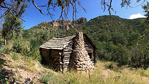
West Divide Trail eventually leaves Redfield Canyon and winds across the high rolling country that separates it from Rattlesnake Canyon. Along the way, it passes the old mine and cabin where the pioneer Power family was involved in a shootout that became part of the mythos of the wild west. The trail then ascends Grassy Ridge where the views are big, bold and unobstructed. To the east, north and south, the major peaks of the Galiuro Range are visible, including Kennedy, Kielberg, Bassett and Biscuit. To the west, the Santa Catalina Mountains north of Tucson stand massive and tall, rising abruptly from the broad, flat San Pedro Valley. Within that valley lies the copper mining town of San Manuel, home of one of the largest open pit copper mines in the world. The trail ends at Maverick Peak, one of the higher points in the Galiuros and one of the major features in the visual smorgasbord you’ll be enjoying as you trek across the ridgetops.

2012-03-14 HAZ_Hikebot


    Check out the Official Route and Triplogs.

    Note
    This is a difficult hike. It would be insane to attempt this entire hike without prior experience hiking.
    Leave No Trace and +Add a Triplog after your hike to support this local community.

    One-Way Notice
    This hike is listed as One-Way.

    When hiking several trails on a single "hike", log it with a generic name that describes the hike. Then link the trails traveled, check out the example.
    WARNING! Hiking and outdoor related sports can be dangerous. Be responsible and prepare for the trip. Study the area you are entering and plan accordingly. Dress for the current and unexpected weather changes. Take plenty of water. Never go alone. Make an itinerary with your plan(s), route(s), destination(s) and expected return time. Give your itinerary to trusted family and/or friends.

     Permit $$
    no fees or permits reported

    if incorrect tell us about it

    Coronado Forest
    MVUMs are rarely necessary to review unless mentioned in the description or directions
    Coronado Motor Vehicle Use Maps (MVUMs)


     Directions
    or
     Road


    To hike
    From the Muleshoe Ranch (Hookers Hot Springs on the Forest Service map), take Forest Road 691 north 13.5 miles to just before Jackson cabin. This is a rough, 4-wheel drive road. From the north, access may be gained by the Powers Garden Trail #96.
    page created by joebartels on Mar 14 2012 12:00 am
     90+° 8am - 6pm kills
    helpcorrectionissue

    end of page marker