 Route Editor

| Guide | ♦ | 19 Triplogs | 0 Topics |
details | drive | permit | forecast | route |
stats |
photos | triplogs | topics | location |
| 197 | 19 | 0 |
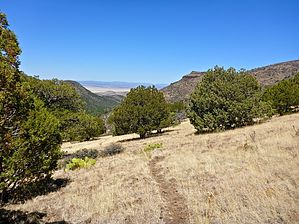
I wouldn't be here if it weren't part of a loop by GrangerGuy   Overview OverviewRick Tank Cutoff Trail #104 is a little-used trail within the Woodchute Wilderness. It can be accessed about 2.2 miles from the southern end of Woodchute Trail #102, or from the very rough jeep trail, Martin Canyon Trail #103. It follows a ravine most of the way, sometimes in the bottom of the canyon, sometimes well up on the side. When the grass is tall, it may be hard to follow. History The wilderness was established in 1984 under the Arizona Wilderness Act of 1984, driven largely by Arizona Representative Morris “Mo” Udall and Senator Barry Goldwater. It became Public Law 98-406 when signed by President Reagan.
The best access to this trail is the parking at Woodchute Trailhead for trail #102. This trailhead is accessible by standard cars. Hike 2.2 miles on a mostly level trail along Trail #102 to the intersection with Trail #104 at Woodchute Tank. To reach the lower end of the trail, you can park in the same place, and hike Road 106D, 106E, 9710W, and Martin Canyon Trail #103. Thus, there is a pure loop, which you can find in the guide for the Woodchute - Martin Canyon Loop. Hike Upon leaving the intersection with Woodchute Trail #102, the trail climbs just a little to upper Woodchute Tank. When full, this is a pretty little lake with grass and flowers up to the edge. Turn left at the tank and walk along the dam, to find the trail out the other side. It goes up slightly and then begins its long descent. The trail first drops into the bottom of a ravine and then stays higher on the side of the hill as the ravine drops away. The trail descends at a reasonable pitch, traversing the hillside and taking occasional switchbacks to lose altitude. Although the trail is well marked with cairns, in some seasons the cairns and trail may disappear entirely in the tall grass and wildflowers. Pay close attention, and if the trail seems to have disappeared, return to the last cairn and try again. Near the bottom, the trail crosses the ravine at what is likely a seasonal waterfall, crosses back and climbs briefly, and then descends for one final crossing before leaving the wilderness and ending at the 4x4 Martin Canyon Trail #103. Flora I saw prickly pear, hedgehog cactus, longleaf false goldeneye, and Stansbury's Cliffrose along this trail. Check out the Official Route and Triplogs. Leave No Trace and +Add a Triplog after your hike to support this local community. One-Way Notice This hike is listed as One-Way. When hiking several trails on a single "hike", log it with a generic name that describes the hike. Then link the trails traveled, check out the example. | |||||||||||||||||||||||||||||||||||||||||||||||||||||||||||||||||||||||||||||||||||||||||||||||||||||||||||||||||||||||||||||||||||||||||||||||||||||||||||||||||||||||||||||||||||||||||||||||||||||||||


