 Route Editor

| Guide | ♦ | 594 Triplogs | 0 Topics |
details | drive | no permit | forecast | route |
stats |
photos | triplogs | topics | location |
| 586 | 594 | 0 |
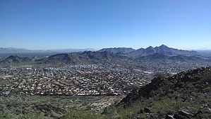
extreme split personality by joebartels  Overview OverviewNorth Mountain National Trail #44 has a north and south trailhead with the summit above and between the two trailheads. It is perhaps the most varied 1.5 miles of trail in the Valley. 75% of the popular north is smooth asphalt. 25% of the south is loose gravel with a few awkward steep spots. Halfway to near the summit is most often hiked as an out-n-back from the north. You can do the same from the south or make a loop by walking the road or the interpretive / spider-maze trails between restrooms.
Hike Since the North lot is encountered first and most popular, I'll describe north to south. North TH to end of the road The first 0.15 miles and only natural surface heading up is the same choppy pre-Cambrian period gneiss and schist as Piestewa. All these hills are but it has the same distinctive use-worn look as Piestewa. There are no flat breather segments, it's game on from step one. After the trail is asphalt on up. There is a hard-packed trail adjacent-right for a large segment. Albeit busy at times, the road width reduces the in-season conga line better than Camelback, Piestewa, or the north leg of this trail. Folks tend to break at the road curves but it basically a steady 16.5% grade. Around 2020 the road was repaved and they put up a pipe railing fence. The road ends just shy of the fenced-off summit. #44 forks off left to the public summit just before the end of the road. I don't hike here often but it seems more go to the end of the road now vs the faux summit. Top down to South TH The footing is initially good as the trail zigzags around rock obstacles. The grade is 21% overall. For reference, that's slightly more than Piestewa and Slightly less than Camelback. The game-changer is roughly 0.2 miles of the mid-portion with loose footing and two steep inclines. Views south down Central Ave into downtown Phoenix give you more of a city feel than Piestewa or Camelback. The only questionable turn is above a house at the saddle, turn left/east. After ~50 feet it's more of a casual three switchbacks down. Facilities Restrooms are prison-style, doorless stalls. That said, they are maintained and fully functioning. There is a high-flow water spigot at the South TH, I didn't check the North. Synopsis Both sides have positives & negatives. The south is more my style, but the footing is too sketchy for my lack of balance in-season because the locals are quick. I'm not talking about stereotype college athletes. Families, toddlers to grandparents that put me to shame. I'm not kidding; it's scary and inspiring alike. Check out the Official Route and Triplogs. Leave No Trace and +Add a Triplog after your hike to support this local community. One-Way Notice This hike is listed as One-Way. When hiking several trails on a single "hike", log it with a generic name that describes the hike. Then link the trails traveled, check out the example. | |||||||||||||||||||||||||||||||||||||||||||||||||||||||||||||||||||||||||||||||||||||||||||||||||||||||||||||||||||||||||||||||||||||||||||||||||||||||||||||||||||||||||||||


