Route Editor

| Guide | ♦ | 7 Triplogs | 0 Topics |
details | drive | permit | forecast | route |
stats |
photos | triplogs | topics | location |
| 45 | 7 | 0 |
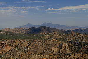
  Background BackgroundVeteran's Peak is just ten feet below the highest point in the Patagonia Mountains, Mount Washington. Mount Washington is its sister peak to the southeast and is slightly less accessible. Reaching the trailhead affords one the opportunity to travel the Border Road and make numerous stops at historically significant sites, if so inclined. The view atop the peak is equally splendid gazing south into Mexico or north toward the Santa Ritas. Numerous old mines dot the landscape in the area and their tilings add color to the view into the foothills beyond the trail. The exact source of the name for Veteran's peak is unknown, but it is said that locals to the area have been referring to it that way for as long as any can remember. Hike The trail is fairly well-worn for most of its course. It departs on the southeastern side (Nogales side) of the cattle guard; do not take the trail on the western side (Sierra Vista side) of the cattle guard, as it tracks for only a short distance and then dissipates. We marked the trailhead with several large cairns in the summer of 2008, but they may or may not still be present. We also left cairns at some of the trickier junctions and turns along the way. The trail begins to climb into the dense scrub oak and pinyon forest that predominates the hillside. The trail is a single-width footpath that is relatively well-worn. It was probably first built to service the radio tower atop the peak, or possibly by a miner. It is sandy in some areas, and rocky in others, but the trail never offers any real technical challenge. At times it begins to resemble a game trail and gets lost in the under-story. In all such cases rejoining the trail only requires a minute or two of fanning out to locate its path.
Author's Note: This fence is *not* the US-Mexico border; the border is 2.2 miles to the south. Leaving the top of 7100, The trail passes by several large boulders and then drops into a minor saddle between peak 7100 and Veterans. Here the trail begins to be intersected every hundred meters or so by foot trails heading north from Mexico and worn in by migrants. The trail is heavily littered at these intersections by clothing and other refuse that bears labels written in Spanish. Continue eastward at all such intersections and stay on the north side of the fence to ensure you are on the trail. After winding slightly northward and continuing for about two hundred meters, the trail begins to climb again, this time toward Veteran's Peak. This final section of the trail requires one short scramble up a nearly vertical section of stony rubble and offers a fair grade throughout. The trail climbs sharply into the summit and approaches a radio tower buried in between the trees. The tower is roughly fifty meters off the trail to the north and likely belongs to the Federal Government. A trail register is stashed away in the rocks near the tower. The summit is forested by pinyon and alligator juniper, but climbing atop the large boulders in the area allows sweeping views in all directions. Return by the same route and avoid leaving the trail by one of the many intersecting paths. Check out the Official Route and Triplogs. Leave No Trace and +Add a Triplog after your hike to support this local community. | ||||||||||||||||||||||||||||||||||||||||||||||||||||||||||||||||||||||||||||||||||||||||||||||