 Route Editor

| Guide | ♦ | 8 Triplogs | 0 Topics |
details | drive | no permit | forecast | map |
stats |
photos | triplogs | topics | location |
| 54 | 8 | 0 |
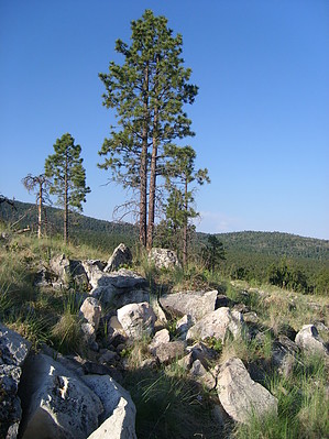
Geology Fieldtrip! by hippiepunkpirate  Nobody hikes the White Horse Hills for their beauty. The Hochderffer Fire of 1996 ravished the forests of the White Horse Hills, leaving the land solemn and barren but also exposing the underlying geology. These hills are an exposed laccolith, an extrusion of igneous rock between sedimentary rock layers, bending the sedimentary layers upward and then uniquely exposing them by erosion. The point of hiking the White Horse Hills is to get into the geological aspects, so do your homework. Learn the finer points of a laccolith and the sedimentary rocks of this section of the Colorado Plateau. I recommend A Guide to the Geology of the Flagstaff Area by John V. Bezy. Nobody hikes the White Horse Hills for their beauty. The Hochderffer Fire of 1996 ravished the forests of the White Horse Hills, leaving the land solemn and barren but also exposing the underlying geology. These hills are an exposed laccolith, an extrusion of igneous rock between sedimentary rock layers, bending the sedimentary layers upward and then uniquely exposing them by erosion. The point of hiking the White Horse Hills is to get into the geological aspects, so do your homework. Learn the finer points of a laccolith and the sedimentary rocks of this section of the Colorado Plateau. I recommend A Guide to the Geology of the Flagstaff Area by John V. Bezy.Warning This trail is definitely not maintained by the Forest Service and has not since the fire. Trees have fallen all over the trail, so the going is rough and not very well defined in some places. Prepare to do some bushwacking! It is also noteworthy that the goal of this hike is to reach the hill in the center, which is also the largest. If you lose the trail completely, you can always head through the grass and up the hill. You'll reach the trail again eventually, and it is pretty darn hard to get lost out here.
The trail starts immediately uphill from the trailhead, and this is really the only forested section of the trail. Soon hill becomes less steep, and you enter the burn area. The hill directly to your left is formed by the uplifted top layer of Kaibab Limestone worn away to the outer hills. At this point, the trail has turned to grass and fallen trees. Look to the small saddle directly ahead, where you can see the trail cutting through the grass again and head for this point. You will notice a few smaller hills all in a row just to the left of the saddle you are heading toward. Coconino Sandstone forms the first. If you take a side trip out to the top, you can see some exposed layers uplifted at about a 45-degree angle. The next couple of hills look to be formed by Schnebly Hill Sandstone. Once you reach the saddle, the trail is relatively flat for a while and then come to a fork. The downhill trail to the right heads to the northern section of the hills, so take the uphill trail to the left. The red sandstones of the Supai Group now appear with a few exposed pieces of the rhyolite core. The trail switchbacks a couple of times and then gets really rocky near the top. Here is the coolest part! The gray rocks tilted past forty-five degrees are Redwall Limestone (they are their true color of gray here because they haven't been stained from above by the Supai Group). Redwall Limestone is located about halfway down in the Grand Canyon, but here it has been pushed up to about 9,000 feet. There have definitely been some strong geologic forces at play! Some of the Red Wall pieces have holes drilled in them, which I assume were made by geologists to take core samples. The trail winds back to a saddle then up to the top of the central hill. Along with some very decent panoramic views of the San Francisco Peaks, Kendrick Mountain, and the surrounding cinder cones, you should be enjoying some solitude because hardly anybody ever comes up here. Notice some cool-looking Rhyolite boulders that form the intrusion that caused these hills to come to be. I estimated the one-way distance as 1.5 miles to the top, but it may be more or less, especially if you go off-trail. Check out the Triplogs. Leave No Trace and +Add a Triplog after your hike to support this local community. One-Way Notice This hike is listed as One-Way. When hiking several trails on a single "hike", log it with a generic name that describes the hike. Then link the trails traveled, check out the example. | ||||||||||||||||||||||||||||||||||||||||||||||||||||||||||||||||||||||||||||||||


