 Route Editor

| Guide | ♦ | 17 Triplogs | 0 Topics |
details | drive | permit | forecast | 🔥 route |
stats |
photos | triplogs | topics | location |
| 114 | 17 | 0 |
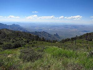
Down the Mountain and Up Again by dieanotherday15  Restrictions: Until October 2021, these trails will be closed due to fire damage: article Restrictions: Until October 2021, these trails will be closed due to fire damage: articleOverview Many people go to Mt Lemmon each year and explore the front side of it on trails such as Wilderness of the Rocks and Marshall Gulch each year, but few explore the northern backside. Here where few tread, the Canada del Oro canyon is lush and full of life with water running through it pretty much perennially.
A similar loop to the one I describe already exists online on the Sierra Club website, to whom I owe most of the route and the idea for it. However, the description is almost 15 years old. A note on the site from 2008 would discourage prospective hikers of the Canada del Oro canyon due to the deteriorated nature of the trails. However, the area has changed since then due to wildfires, and the trail has been vastly improved. The Canada del Oro loop deserves an updated description, and my loop happens to shorten the hike by about a mile and a half :) Hike From the Red Ridge trailhead, you shoot off over the hill and quickly begin a strenuous and challenging descent of more than 3,000 feet in 5 miles. I highly recommend starting this trail early because wildfires have desolated the pines over most of the trail, leaving it very open to direct sunlight later in the day. The wildfires have also replaced the pines with thorny bushes, so long pants are also recommended. After a descent which seems like forever, you should come to a first stream crossing. There was water there when I was there in late June. From here, you should come to Catalina Camp, though there is no sign marking the fact. I honestly didn't even notice the campsite when I was there. Continue past there into the highland desert oakland areas. From here, the trail becomes more difficult and requires some path-finding skills to negotiate the trail at various streambed crossings. Follow the cairns and go slowly, and you should not have too many problems with this part of the trail. After you pass from the highland desert areas, you reach a trail junction for the Canada del Oro trail. Follow the Canada del Oro trail left for 6.1 miles. Very quickly, you begin passing along a stream bed and should see some water in it. Follow the trail and pay attention for cairns and tree markers directing you where the trail is. While the trail was in lousy shape some time back, it was amply improved in winter 2011. You should have few to no problems following the trail as it luxuriously winds through the canyon. Along the way, oaks turn to pines and plant life, and wildflowers spring up everywhere. There's a lot of wildlife down here. I nearly walked into deer multiple times, who don't seem to have known what I was. Also, beware, depending on when you go. I passed two rattlesnakes. After a pleasant walk through the canyon, you cross to the side of the canyon away from Mt Lemmon and begin a blistering ascent up a series of switchbacks, which are quickly over. Right after the switchbacks, you come to a junction for the Canada del Oro shortcut loop. Walk straight ahead to the left of the junction, and you begin ascending the side of Mt Lemmon. Although it doesn't say it on the sign, you're now on the Samaniego Trail, which takes you through a beautiful, cool pine forest, for the most part, over 0.6 miles. After a short while, you come to a trail junction. Turn left and uphill onto the Sutherland Trail for 0.8 miles which winds for a short while through burned pine forest areas until you reach a junction with the Lemmon Trail after a blistering series of steep switchbacks. From the Lemmon Trail Junction, go left and head uphill for a pleasant walk over the trail, which is little more than a jeep road. You have gorgeous views from the trail of most of the mountains and Tucson. Continue on the trail for 0.7 miles until you reach a junction for the Meadow Trail. You can continue on Mount Lemmon Trail #5 for 0.7 miles to the summit, but the Meadow Trail #5A is much prettier and is only 0.8 miles to the summit. It takes you through pine forests and then open beautiful green meadows, which you wouldn't see on the other trail. Shortly after reaching the end of the Meadow Trail, continue straight, and in just a couple of minutes, you will reach the Summit Parking Lot. Stop and enjoy your accomplishment! However, you still have about 2 miles till the end. From the Summit Parking lot, walk down the road to the large dirt parking lot just below the parking lot and turn left onto the dirt road leading by the towers. After 0.3 miles, you should just pass the top of the ski lift, where you will find the Aspen Draw Trail. This trail is a pleasant mild walk through thick pine forests in cool air. It is absolutely lovely and easy to just get lost in the wilderness on this trail despite its proximity to the ski lift. After 1.6 miles, you will reach Ski Run road. Turn right and walk about 0.5 miles back the Red Ridge Trailhead. Check out the Official Route and Triplogs. Note This is a difficult hike. It would be insane to attempt this entire hike without prior experience hiking. Leave No Trace and +Add a Triplog after your hike to support this local community. | |||||||||||||||||||||||||||||||||||||||||||||||||||||||||||||||||||||||||||||||||||||||||||||||||||||||||||


