Route Editor

| Guide | ♦ | 2 Triplogs | 0 Topics |
details | drive | no permit | forecast | 🔥 route |
stats |
photos | triplogs | topics | location |
| 6 | 2 | 0 |
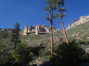
You will break first by nonot   Overview OverviewA Technical Canyoneering trip into a tributary of Sycamore Canyon Warning This is a technical canyoneering trip, you will need a helmet, harness, and rap device, along with 2x100 ft ropes, webbing, and 3-4 quicklinks. Wetsuits only if the weather will be pretty cold. This area was fire damaged and is pretty warm due to lack of shade.
Discovered by Joe and Sara DeSalme, published in Arizona: Technical Canyoneering Hike Hike east on FR127 about 2.5 miles to the drop-in. Head northeast down the drainage, full of New Mexico Locust, Gambel Oak, and many, many fallen and sooty trees. The best approach may be to stay high and out of the canyon for about 0.6 miles. You will reach the first rap of 30 ft rigged from a fallen tree. Continue thrashing downcanyon until it finally starts to slot up as you near Tule Canyon. You will reach a nice slickrock area, soon after you reach the terminal sequence: Rap 2: (currently a downclimb down fallen trees rather than a rap) of 15 feet. Rap 3: (anchor from the boulder before the pool, swim the pool, and rap 65 ft (need about 2x100 ft ropes for this) Rap 4: about 25 feet, immediately after Rap 3 Rap 5: (optional) - most will downclimb on right LDC but you could rig from a tree on left LDC and rap about 30 ft. Hike down canyon and degear at Tule. Hike up (west) Tule wash for a few miles of rock-hopping goodness with a few interesting pools in Coconino slickrock. In fall Arizona grape may provide a snack along the way, just fend off the bears to get your fair share. Water Sources Nothing you'd want to drink. Camping Camping on the rim in the area. Check out the Official Route and Triplogs. Leave No Trace and +Add a Triplog after your hike to support this local community. | |||||||||||||||||||||||||||||||||||||||||||||||||||||||||||||||||||||||||||||||||||||||||||||||||||||||||||||