 Route Editor

| Guide | ♦ | 42 Triplogs | 0 Topics |
details | drive | no permit | forecast | route |
stats |
photos | triplogs | topics | location |
| 87 | 42 | 0 |
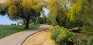
Not FORE! the timid by joebartels  2022 Note 2022 NoteThe route of this trail is being rerouted. Overview Connects Trail #100 with Lookout Mtn Circ Trail #308. Majority of hike is through Pointe Hilton Tapatio Cliffs golf course. Experience Troon Golf while praying nobody yells at you. Hike North and South ends of this trail are well established and signed. The core of the hike through the golf course is questionable.
The Official Route is the best I could figure out based on park data and posts on HAZ. Thanks to Dave for getting a prototype route out years ago. Water Sources Bring all the water you need. Three water fountains along the course/trail. Obviously not public property. Two Out-n-Back options with parking, water and restrooms. South North Mountain Visitor Center Hours Vary 12950 N 7th St, Phoenix, AZ 85022 Trail #100 SE of lot, follow E under Tunnel to #25 Adds 1.1 mi / 120 ft AEG Roundtrip North Lookout Mountain Park 5:30 a.m. to 7 p.m. 14441 N 18th St Parking Use-trail W from parking, then on #308 N then W to #25 Adds 0.65 mi / 110 ft AEG Roundtrip Synopsis Guessing this is an old Phoenix Preserves easement. There is no way an organization with a goal to create extraordinary guest and member experiences want hikers walking their course. Odd and cool all in one. An unforgettable experience. Check out the Official Route and Triplogs. Leave No Trace and +Add a Triplog after your hike to support this local community. One-Way Notice This hike is listed as One-Way. When hiking several trails on a single "hike", log it with a generic name that describes the hike. Then link the trails traveled, check out the example. | ||||||||||||||||||||||||||||||||||||||||||||||||||||||||||||||||||||||||||||||||||||||||||||||||||||||||||||||||||||||||||||||||||||||||||||||||||||||||||||||||||||||||||||


