 Route Editor

| Guide | ♦ | 2 Triplogs | 0 Topics |
details | drive | permit | forecast | route |
stats |
photos | triplogs | topics | location |
| 64 | 2 | 0 |
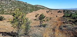
you deserve better by joebartels   April 2020 Note April 2020 NoteThe FS website says Temporarily CLOSED for rehabilitation following the Goodwin Fire. Work is expected to be completed by the end of 2017. Obey all official signage. Overview Notably used with Charcoal Gulch Trail #9419 for a lasso loop. Southern 0.7 mi to FS 9404T is unlikely used by anyone driving over 50 miles for a hike.
Park at Green Gulch TH. Take Charcoal Gulch Trail #9419 0.45 miles. Turn left/south onto Nemo Spring Trail #9405. Hike In 60 yards, the trail crosses Green Gulch, which is an intermittent creek. If you came in search of shade, this is the nicest opportunity. The trail is 99% uncovered. A little over a half-mile in, you enter a wide firebreak for Dewey-Humbolt. The moonscape is within the last three years. The 2017 Goodwin Fire boundary is about three miles south of this trail. Soon you visit ❤ Joe's Tank ❤. The trail climbs aggressively up and away from the tank. Fear not, it's over quick in 75 vertical feet. You are back in the firebreak for almost a mile sandwiched on the edge of the mountains/west and Dewey-Humbolt/east. Fain Tank is the next hurrah. The trail seems to go directly through the tank. Getting around isn't an issue. Then it's a steep grade up, leaving mom, apple pie, and Dewey-Humbolt. Tread is rocky. Not horrible for hikers going up. I'd imagine semi-undesirable descending and a mess for mountain biking in either direction. The ascent is 0.75 mi / 500 ft. Then you dip through a gentle contour before a short steep descent on route to the namesake. Nemo Spring is extremely popular with the local bovine community. The trail skirts a tank. A water trough in eyesight was kinna gross on my visit. The spring itself is about 200 ft west according to topo. I did not come prepared to wade through ankle-deep cow-shit-infused mud to check it out. 0.3 miles further is Charcoal Gulch Trail #9419 and the end of this trail for most. Nemo does continue 0.7 mi down to FR 9404T. Synopsis Intriguing for me on a cool morning, no desire to return. A mile of my hike was between two clicks of angry cows, entertaining.
Check out the Official Route and Triplogs. Leave No Trace and +Add a Triplog after your hike to support this local community. One-Way Notice This hike is listed as One-Way. When hiking several trails on a single "hike", log it with a generic name that describes the hike. Then link the trails traveled, check out the example. | ||||||||||||||||||||||||||||||||||||||||||||||||||||||||||||||||||||||||


