 Route Editor

| Guide | ♦ | 15 Triplogs | 0 Topics |
details | drive | permit | forecast | 🔥 route |
stats |
photos | triplogs | topics | location |
| 226 | 15 | 0 |
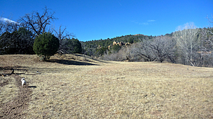
To B or not to B by chumley   Overview OverviewThis trail is the easiest access point for the Apache Creek Wilderness. While this trail never actually enters the Wilderness, it ends at the boundary and at the north end of the Apache Creek Trail #9905. It is the only official access to the northern portion of the Wilderness, which is otherwise surrounded by private property where hiking is not permitted. Trailhead Access As described in the directions below, this trail begins from a marked trailhead on Forest Road 95A. There is parking for one or two vehicles only. This road gets progressively more difficult to drive the farther from FR95 it gets, and while a stock 4x4 truck can make it to the trailhead, the travel is so slow that it probably makes more sense to just walk. Hiking a portion of the road is not included in the stats for this hike.
All the signs you find posted along this trail and others in the Apache Creek Wilderness indicate this as Graber Wash Trail - rather than Graver. I assume this was a mistake in verbal communication to the signmaker since B and V are easily confused. But all the maps I've ever seen identify the nearby wash as Graver. So B or V? Don't let it confuse you too much. Either way, you're on the right trail! Hike From the trailhead, proceed north through a little wash and up the hill on the other side, where you will encounter a lovely information board and sign-in box. From here, the trail descends slowly through primarily pinyon and juniper. After about half a mile, the trail begins to parallel a dry wash, and you may occasionally find a bit of surface water from a seep along the way. At 0.9 miles, the trail takes a turn to the west, following the contour of the drainage you have been walking down. Straight ahead and downhill, you may see a corral that belongs to private ranch property adjacent to the Wilderness. Next, the trail then descends gently into the perennial Apache Creek, where you can use boulders to cross without getting wet before following the cairned route up the slope on the other side. From here, cairns lead you up into a grassy meadow north of the creek, where it ends at the Wilderness Boundary and junction with the Apache Creek Trail #9905. There are numerous shade trees here that make for a nice relaxing picnic spot, or you may explore off-trail to a creekside location. Connecting Hikes From the end of this trail, you can enter the Apache Creek Wilderness by hiking south on trail #9905. If you wish to make a loop, Upper Graver Wash Trail #9906 leaves the wilderness and connects back to Forest Road 95A, which you can use to return to the trailhead for a total of about 6.5 miles. Check out the Official Route and Triplogs. Leave No Trace and +Add a Triplog after your hike to support this local community. One-Way Notice This hike is listed as One-Way. When hiking several trails on a single "hike", log it with a generic name that describes the hike. Then link the trails traveled, check out the example. | ||||||||||||||||||||||||||||||||||||||||||||||||||||||||||||||||||||||||||||||||||||||||||||||||||||||||||||||||||||||||||||||||||||||||||||||||||||||||||||||||||||||||||||||||||||||||||||||||||||||||||


