 Route Editor

| Guide | ♦ | 24 Triplogs | 0 Topics |
details | drive | permit | forecast | 🔥 route |
stats |
photos | triplogs | topics | location |
| 389 | 24 | 0 |
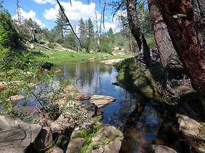
Apache Crown Jewel by chumley   Overview: The Apache Creek Trail is the only maintained trail in the 5,666-acre Apache Creek Wilderness. It begins at the southern wilderness boundary, travels north for a little over 2 miles before joining the perennial Apache Creek, and continues an additional 3 miles to its terminus near the north edge of the wilderness and the junction with the Graver Wash Trail. Overview: The Apache Creek Trail is the only maintained trail in the 5,666-acre Apache Creek Wilderness. It begins at the southern wilderness boundary, travels north for a little over 2 miles before joining the perennial Apache Creek, and continues an additional 3 miles to its terminus near the north edge of the wilderness and the junction with the Graver Wash Trail.History: The Apache Creek Wilderness was established in 1984. It features rolling hills of juniper, pinion, and ponderosa groves with numerous granite boulders and outcroppings. AZGFD reports that this area has the highest concentration of mountain lions in the state, which indicates a healthy population of deer. Also found are ample populations of black bears, rabbits, and birds of prey.
Hike: The south trailhead is not marked with any signs. Some cairns on the road indicate your turn across a small meadow before you encounter the Apache Creek Wilderness sign and the obvious trail. Heading north this lightly-used trail is reasonably well marked with cairns. If you lose the route it takes only a few seconds of searching to reacquire your bearings. The trail meanders slowly downhill through large granite boulders and outcroppings. The flora is not dense and includes scattered ponderosa, pinion, juniper, and oak. After 2.3 miles, the trail joins the perennial Apache Creek, where a trickle of water apparently runs year-round. The sandy geology here may result in the creek occasionally running underground during the drier months of the year. At the 3.6 mile mark, you reach the marked junction with the Upper Graver Wash Trail, which leads out of the wilderness to the east, and up to Forest Road 95A (also not accessible by stock vehicles. Modified trucks or OHVs only). The final two miles follow the bank of the creek to the terminus of the trail where it intersects the Lower Graver Wash Trail in a large meadow just a short distance from County Road 125, and several large ranches. Along the way, the trail crosses Apache Creek a few times, most of which can be done by keeping your feet dry, but during higher creek flow you might have to get your shoes wet. Water: While at least some water should be available in Apache Creek year-round, this area is heavily grazed by cattle. Treat all water before drinking. Camping: Due to the difficulty of accessing this wilderness, backpacking is a great option to allow for exploration and enjoyment here. There are no developed camping areas, but plenty of flat ground and shaded opportunities exist all along this trail. Please follow wilderness etiquette. If you choose to camp, please do so 100 feet from the trail and 100 feet from the water. Bury all waste and pack out all toilet paper and trash. If you build a fire ring (please check for current fire restrictions which are common in spring and summer), please destroy it when you are done. Check out the Official Route and Triplogs. Leave No Trace and +Add a Triplog after your hike to support this local community. One-Way Notice This hike is listed as One-Way. When hiking several trails on a single "hike", log it with a generic name that describes the hike. Then link the trails traveled, check out the example. | |||||||||||||||||||||||||||||||||||||||||||||||||||||||||||||||||||||||||||||||||||||||||||||||||||||||||||||||||||||||||||||||||||||||||||||||||||||||||||||||||||||||||||||||||||||||||||||||||||||||||


