username
X
password
register
for free!
help
  🔥

West Fork Trail #260, AZ

Guide 35 Triplogs  0 Topics
  2.7 of 5  
Fav
Wish
1
details
drive
no permit
forecast
🔥
route  
stats
photos
triplogs
topics
location
116 35 0
Statistics
tap row or icons for details
Difficulty 2 of 5
Route Finding 1 of 5
Distance One Way 0.9 miles
Trailhead Elevation 4,710 feet
Elevation Gain 487 feet
Accumulated Gain 488 feet
Avg Time One Way .5
Kokopelli Seeds 2.53
 Interest Seasonal Creek
 Backpack Yes & Connecting
unreported if dogs are allowed
editedit > ops > dogs to adjust
feature photo
Photos Viewed All MineFollowing
Will recalculate on button tap!
6  2025-03-25
Mazatzal Loop
Layne32
23  2024-12-07
Saddle Mountain Mine Tour
DarthStiller
27  2024-12-07
Saddle Mountain Mine Tour
adilling
20  2024-12-07
Saddle Mountain Mine Tour
wallyfrack
24  2024-05-24
Cornucopia West Fork Thicket Spring
CannondaleKid
6  2021-10-23
Cornucopia Trail #86
FOTG
5  2021-02-12
Saddle Mountain Loop
LJW
10  2018-10-21
Thicketopia
chumley
Page 1,  2,  3
Author
author avatar Guides 38
Routes 182
Photos 1,602
Trips 232 map ( 2,731 miles )
Age 40 Male Gender
Location Gilbert, AZ
Associated Areas
list map done
Payson Region
Historical Weather
Trailhead Forecast
Radar Map
Expand Map
Preferred Apr, Oct, Mar, Nov
Sun  6:01am - 6:48pm
Official Route & 1 Rt
 
12 Alternative
 
Historic Fire Perimetersacres
🔥 2020 Bush Fire193.5k
🔥 2012 Sunflower Fire16.1k
🔥 2004 Willow Fire120k
🔥 2004 Willow117.2 mi*
🔥 View (All) - over Official Route 🔥
*perimeter length in miles


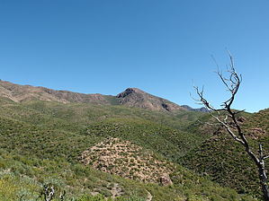
Quick Climb from Cornucopia
by jacobemerick

Overview:
A steep climb up a manzanita hillside from Cornucopia to Thicket Springs Trail. A segment of AZT #22 (recently re-routed) and an integral part of the classic Cornucopia - Thicket Spring Loop. The 'trailhead' is not easily accessible unless you have a vehicle that can handle 25A.


Hike:
If you're on this trail, chances are that you are doing some sort of thru-hike or loop (like the one linked above) and have reached West Fork Trail by hiking other trails. The alternative is that you drove (or walked) up 25A along Sycamore Creek until it ended, and then walked the short connector to the Cornucopia / West Fork junction. However you get there, this description starts at the trail's east end.
remove free decal offer
A busy signpost marks the junction of Cornucopia / West Fork trails, with West Fork heading up and to the left. Seasonal pools may be found in the creek bed here along Cornucopia Trail - this is the only water source for a while. Start climbing up, heading back and forth along the one switchback, passing burnt trunks rising over the younger growth in an eery combination. Below there are views of Cornucopia dancing along the creek bank.

At 0.4 miles the trail turns west in earnest and continues uphill, with a few good angles of Mount Peeley to the north and Saddle Mountain to the southwest along the way. The route goes up through a saddle and then drops softly to end at Thistle Spring Trail. From here you can turn left towards Saddle Mountain and MacFarland Canyon or turn right towards Peeley. Lots of loop options and all-day meanders are available.

Water Sources:
Seasonal pools may be found along Cornucopia Trail.

Camping:
No good flat spots are along this short connecting trail.

2017-06-27 jacobemerick


    Check out the Official Route and Triplogs.
    Leave No Trace and +Add a Triplog after your hike to support this local community.

    One-Way Notice
    This hike is listed as One-Way.

    When hiking several trails on a single "hike", log it with a generic name that describes the hike. Then link the trails traveled, check out the example.
    WARNING! Hiking and outdoor related sports can be dangerous. Be responsible and prepare for the trip. Study the area you are entering and plan accordingly. Dress for the current and unexpected weather changes. Take plenty of water. Never go alone. Make an itinerary with your plan(s), route(s), destination(s) and expected return time. Give your itinerary to trusted family and/or friends.

     Permit $$
    None


     Directions
    or
     Road
    Connector trail - Not Applicable

    To hike
    FR 25A is ridiculous - 4WD, High Clearance, and lots of Grit required to drive. Either that or walk it from FR 25.
    page created by joebartels on Jun 16 2017 2:58 pm
     90+° 8am - 6pm kills
    helpcorrectionissue

    end of page marker