 Route Editor

| Guide | ♦ | 10 Triplogs | 0 Topics |
details | drive | no permit | forecast | 🔥 route |
stats |
photos | triplogs | topics | location |
| 176 | 10 | 0 |
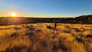
Plan a group hike here and it'll be the last by joebartels  Warning WarningFew, very few, will want to hike this trail. The 2020 Bush Fire zipped across the area. It is a well cairned route. The ATV crowd is a staple of the area. Pants are recommended, I hate 'em but they are necessary. Gaiters might be preferred... cursing is cheaper, cooler, and lighter weight. Overview Connects Cottonwood Camp to FR401. From FR401 it is an easy 0.6-mi road walk to Soldier Camp TH, the origin of a different nightmare Soldier Camp Trail #83.
The first mile was formerly a whacky jungle. That is gone, it is now an easy wide flat wash. There wasn't much loss on the upper ridge-half of the hike because there was little vegetation before the fire. There is catclaw but honestly is not much concern. Avoidable for the most part, not through it if paying attention. Hike The only hint of signage is the top. As mentioned above, the first mile is walking the wash. Right near a mile, the trail begins heading up. There is a good cairn as of this writing and they continue to the top. One nasty bush just after the first cairn is making the trail a challenge to understand. Take the bitch out or go around the left. It's clear sailing to the top. Well... it's knee-high grass covering the trail with rocks, cactus, possibly snakes, and a cairn hunt. Most of the ridge is concentrating on the footing, check out the distant views on occasion. Synopsis Views from the ridge are nice and it offers extended options for strong-off-trail explorers. The ATV crowd gets a bad rap and intimidates some but has been more friendly than not in at least a dozen of my hikes out of Cottonwood Camp spanning three decades. Motorcycles are common. They like to go fast, shoot and have a good time. I've been offered rides more than once, food, and beer once. Arrive early and leave late for the least interactions. Lower Soldier Camp Trail #84 is an option for those without four-wheel drive, it's close to the Valley, it's not crowded, and it's a good way to add a little to the Four Peaks Circumference. Check out the Official Route and Triplogs. Leave No Trace and +Add a Triplog after your hike to support this local community. One-Way Notice This hike is listed as One-Way. When hiking several trails on a single "hike", log it with a generic name that describes the hike. Then link the trails traveled, check out the example. | ||||||||||||||||||||||||||||||||||||||||||||||||||||||||||||||||||||||||||||||||||||||||||||||||||||||||||||||||||||||||||||||||||||||||||||||||||||||||||||||||||||||||||||||||||||||||||||||||||


