 Route Editor

| Guide | ♦ | 48 Triplogs | 0 Topics |
details | drive | no permit | forecast | 🔥 route |
stats |
photos | triplogs | topics | location |
| 291 | 48 | 0 |
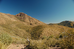
One Thick Trail by jacobemerick   Overview: Overview:Staggered climb out of McFarland Canyon, past West Fork Trail, along Sheep Mountain, and ending near Thicket Spring at Cornucopia Trail. This trail is a piece of the classic Cornucopia - Thicket Spring Loop and a part of AZT #22. Reaching the trail can be done from Cornucopia via Peeley Trailhead, West Fork via 25A, or Sheep Creek/Saddle Mountain via Mormon Grove. This description will start from the Sheep Creek junction. History: Much of this area was damaged by the 2012 Sunflower Fire. This entire trail was once part of the Arizona Trail, but now only the southern half is, with the AZT utilizing West Fork and Cornucopia instead.
Tall pines and a pleasant campsite sit in McFarland Canyon at the start of this trail, near the Sheep Creek junction. From here the trail follows McFarland northeast, sticking to the northern bank, to .3 miles. It then climbs a short saddle and follows a tributary up towards West Fork Trail at 1.1 miles, gaining a few hundred feet along the way. The last section of this climb drops directly into a gentle shale-lined drainage that makes for easy hiking. Some good views back at Saddle Mountain and McFarland can be had along this climb. From here the AZT leaves down West Fork and the rest of Thicket Spring may be a bit more wild without the extra traffic. The trail continues to climb, staying inside the drainage as it narrows and steepens, jumping out at 1.3 miles. The next climb is up an exposed hillside and can be quite tiring in the full sun. It crests at 1.7 miles, and here it is mandatory to take a break and enjoy the expansive views of Mt Ord and Four Peaks in the distance and the closer Saddle Mountain. A short drop down into a drainage is on the other side of the crest, with large cairns marking the way across the rocky beds, and then another quick climb to 2.0 miles. Mount Peeley towers to the north, a mere mile away at this point. The trail now slinks downhill, losing four hundred feet along the east bank of a tributary of West Fork Sycamore Creek. The brush can get thick along this section, though the path is never hard to pick out. A well-signed trailpost marks the end of this trail and the junction of Cornucopia. Water Sources: Upper McFarland Spring at the junction is pretty reliable, and McFarland Creek along the trail may have trickling pools as well. Some water may be found near Thicket Spring as well. Camping: There is a great campsite at the Sheep Creek / Thicket Spring junction in McFarland and some possibilities near Thicket Spring on the other end of the trail. Check out the Official Route and Triplogs. Leave No Trace and +Add a Triplog after your hike to support this local community. One-Way Notice This hike is listed as One-Way. When hiking several trails on a single "hike", log it with a generic name that describes the hike. Then link the trails traveled, check out the example. | ||||||||||||||||||||||||||||||||||||||||||||||||||||||||||||||||||||||||||||||||||||||||||||||||||||||||||||||||||||||||||||||||||||||||||||||||||||||||||||||||||||||||||||||||||||||||||||||||||||||||||||||||||||||


