 Route Editor

| Guide | ♦ | 27 Triplogs | 1 Topic |
details | drive | no permit | forecast | 🔥 route |
stats |
photos | triplogs | topic | location |
| 153 | 27 | 1 |
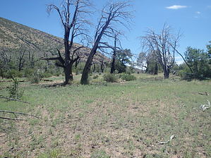
Painful Option to Upper Barnhardt by jacobemerick   Overview OverviewThis trail provides an option to the upper two miles of Barnhardt Trail and makes a connection along the Mazatzal Divide that is perfect for hikers aiming for Horse Camp Seep or Deadman Falls. It can be combined with Barnhardt to do a challenging 15 mile dayhike or any number of longer loops involving Rock Creek Trail or even some of the western trails (see Club Cabin for inspiration). Warning This trail was damaged in the Willow Fire of '04 and has not seen maintenance in a long time. Sections of tread are washed out, and most of the path is overgrown with manzanita. There are few cairns and practically no traffic to assist with route-finding. Do not expect to travel faster than a mile/hour.
Sandy Saddle Trail starts about 3.5 miles along the Barnhardt Trail (from Barnhardt Trailhead). The junction is marked with a few cairns, and for the first few dozen yards, the trail is easy to follow down the slope. It turns west and swings inwards, crossing a drainage, and steadily worsens as it follows the heavily vegetated hillside in and out. At 0.4 miles it turns north and follows a large drainage towards Castersen Seep. Dropping into this drainage may prove easier than route-finding along the bank. Beyond the seep, the trail hauls up the north bank, then begins twisting around the tip of a ridge, staying mostly level as it offers good views to the east. Things are much easier to track here thanks to low brush and a few helpful cairns. The brush tends to get a little thick on the shaded side of the ridge, and then the trail drops down to a drainage on the north side at 1.1 miles. A spotty trail may be traceable on the south bank, or else the drainage offers an obvious way forward. At 1.3 miles, a rocky tributary shows up and marks the beginning of the climb. Follow the tributary a few dozen yards and keep an eye out for a good place to cut up the ridge to the right, as the trail is faint here. Once you cut up, aim for the edge of the ridge and follow that uphill, following the path when it's passable and keeping to the edge when it's not. This climb is about 780' and goes through some thick vegetation so... enjoy. Near 1.8 miles, the trail will start bending to the right, away from the edge, and began to level off. There is one deep cut to cross before the last little climb to Sandy Saddle, a small, sandy clearing with some camping potential and limited views. Go west across Sandy Saddle and look for a trail leading downhill through the brush, as it is well-defined and worth finding. It follows a rocky little drainage for a bit before meeting a larger one at 2.4 miles. Here the trail fades out, and it is easier to stick to the drainage as it tumbles downhill, which it does over a mix of easy sandy flats and rockier sections. A path may be traceable near the end on the south bank. Either way, the Mazatzal Divide Trail shows up soon enough and will feel like a highway in comparison. Water Sources Castersen Seep may have some water, especially in the tanks downstream of the trail crossing. Also, there are some rock tanks just west of Sandy Saddle, along the trail. Neither one of these should be depended upon. Camping Sandy Saddle provides a relatively flat area for camping with a twisted, half-dead tree or two for atmosphere. Coupled with the rock tanks to the west, this could be a decent overnight spot off the beaten path of the Mazatzal Divide. Castersen Seep is rumored to be used as a campsite as well, though I've yet to see a reasonable spot along the drainage. Check out the Official Route and Triplogs. Note This is a moderately difficult hike. Leave No Trace and +Add a Triplog after your hike to support this local community. One-Way Notice This hike is listed as One-Way. When hiking several trails on a single "hike", log it with a generic name that describes the hike. Then link the trails traveled, check out the example. | ||||||||||||||||||||||||||||||||||||||||||||||||||||||||||||||||||||||||||||||||||||||||||||||||||||||||||||||||||||||||||||||||||||||||||||||||||||||||||||||||||||||||||||||||||||||||||||||||||||||||||||||||||||


