 Route Editor

| Guide | ♦ | 7 Triplogs | 0 Topics |
details | drive | permit | forecast | 🔥 route |
stats |
photos | triplogs | topics | location |
| 118 | 7 | 0 |
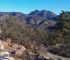
Tough hike with a big payoff! by Booneman  Prepare yourself for a challenging, partially off-trail hike to summit one of the most recognizable peaks in the Chiricahuas! The route begins from the pull-out along Bonita Canyon Drive in Chiricahua National Monument, heading back downhill 0.22 miles on the pavement to an old mining road known as the Horse Trail. It's gated yet accessible to hikers. This road climbs steadily for 1.45 miles past the Wilderness Boundary fence and mine to a saddle where you will encounter the first set of cairns at 7,000ft and 1.67 miles into the hike. Pay attention here as the trail begins and veers NE (to the right). A faint trail exists with a few cairns and becomes very difficult to follow at times for the next mile because of overgrowth and downed trees from the 2011 Horseshoe Two Fire. Cochise Head will be visible now. After traveling for a mile through this section, the trail seems to disappear into a steep wash. Cross the wash, and soon the Woods Canyon/Indian Springs Trail intersection will be present. The sign where these two trails converge should be approximately 2.85 miles into the hike and now leave 1.5 miles remaining to reach the peak. There is no trail present to Cochise Peak except for a few scattered cairns. Follow the ridgeline to the backside of the 4th rock formation and look for a crack in the rock where a hand-over-hand climb on the final approach will be necessary to the peak. Prepare yourself for a challenging, partially off-trail hike to summit one of the most recognizable peaks in the Chiricahuas! The route begins from the pull-out along Bonita Canyon Drive in Chiricahua National Monument, heading back downhill 0.22 miles on the pavement to an old mining road known as the Horse Trail. It's gated yet accessible to hikers. This road climbs steadily for 1.45 miles past the Wilderness Boundary fence and mine to a saddle where you will encounter the first set of cairns at 7,000ft and 1.67 miles into the hike. Pay attention here as the trail begins and veers NE (to the right). A faint trail exists with a few cairns and becomes very difficult to follow at times for the next mile because of overgrowth and downed trees from the 2011 Horseshoe Two Fire. Cochise Head will be visible now. After traveling for a mile through this section, the trail seems to disappear into a steep wash. Cross the wash, and soon the Woods Canyon/Indian Springs Trail intersection will be present. The sign where these two trails converge should be approximately 2.85 miles into the hike and now leave 1.5 miles remaining to reach the peak. There is no trail present to Cochise Peak except for a few scattered cairns. Follow the ridgeline to the backside of the 4th rock formation and look for a crack in the rock where a hand-over-hand climb on the final approach will be necessary to the peak.The reward is definitely the 360-degree view of the Chiricahua Mountains and reaching one of Arizona's top 100 prominent peaks. I would highly recommend hiking in cooler temperatures, as the fire left this area almost completely exposed to the sun. It's also quite overgrown, so long pants and long sleeves would be a good idea. I would consider bringing a GPS and Topo map; good route finding skills will also be helpful. Be smart. Don't hike alone. Bring enough food and water, and let someone know where you are going and when you plan to return. Gate Policy: If a gate is closed upon arrival, leave it closed after you go through. If it is open, leave it open. Leaving a closed gate open may put cattle in danger. Closing an open gate may cut them off from water. Please be respectful, leave gates as found. The exception is signage on the gate directing you otherwise. Check out the Official Route and Triplogs. Note This is a moderately difficult hike. Leave No Trace and +Add a Triplog after your hike to support this local community. One-Way Notice This hike is listed as One-Way. When hiking several trails on a single "hike", log it with a generic name that describes the hike. Then link the trails traveled, check out the example. | ||||||||||||||||||||||||||||||||||||||||||||||||||||||||||||||||||||||||||||||||||||||||||||||||||||||


