 Route Editor

| Guide | ♦ | 1 Triplog | 0 Topics |
details | drive | permit | forecast | route |
stats |
photos | triplog | topics | location |
| 7 | 1 | 0 |
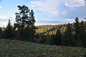
Good sunset walk by markthurman53  The Sacramento Mountains district of the Lincoln National Forest is located in the Southeast section of New Mexico between the Tularosa Basin to the west and the Pecos River Basin to the East. Cloudcroft is the largest town along Highway 82 at the crest of the mountains. Up between 8 and 9000 feet, this is a perfect summer getaway or an excellent area for winter sports. The forests are composed of Douglas Fir, Ponderosa pine, Aspen, and Oak. There is a wide range of wildlife, including Deer, Elk, and Bear. Cloudcroft is a popular recreational site for many kinds of activities, including camping and hiking. There are over 100 miles of hiking trails within 30 miles of Cloudcroft, many of which are along old logging roads, railroad grades, and existing old trails. Views from the ridges of the Sacramento Mountains over the Tularosa Basin are superb, assuming the weather conditions permit. PUMPHOUSERIDGE TRAIL #5661H
The Pumphouse Ridge extends from southeast Cloudcroft and heads in an east southeast direction for about six miles. This ridge forms the main divide between Cox Canyon to the south of Cloudcroft and James Canyon to the east of Cloudcroft. The road FR5661 was a logging road/train bed when this area was logged in the early 1900s. The 5 trails #5661C, D, F, H, and Q are short roads/train beds that emanate from the main Pumphouse Ridge alongside ridges. All these trails are short, with the longest being about 1.6 miles, the rest under a mile. While these trails are not particularly popular hiking trails, they are used with mountain bikers and in the winter snow sports. I found them nice as short walks before sunset after a good meal in Cloudcroft. Description The signed Pumphouse Ridge Trail #5661Q is 6.3 miles in along the Pumphouse Ridge Road. The trail follows along a short ridge that heads in a northeast direction off the main Pumphouse Ridge. This trail is relatively level and follows along the east side of this offshoot ridge. At 0.8 miles in, the trail/road ends at a clearing that looks like it was used as a campsite with a fire pit. The canyon to the east is Hyatt Canyon, and it drains to the north into James Creek. In the summer, there are a lot of flowers along this route, and if you’re not into flowers, the fossils in the limestone rock are quite interesting. In the evening, the elk are numerous along Pumphouse Ridge. Not much else to do when you hit the end of the trail except head back the way you came. Check out the Official Route and Triplog. Leave No Trace and +Add a Triplog after your hike to support this local community. One-Way Notice This hike is listed as One-Way. When hiking several trails on a single "hike", log it with a generic name that describes the hike. Then link the trails traveled, check out the example. | ||||||||||||||||||||||||||||||||||||||||||||||||||||||||||||||||||||||||||||||||||||||


