| Guide | ♦ | 1 Triplog | 0 Topics |
details | drive | permit | forecast | 🔥 route |
stats |
photos | triplog | topics | location |
| 53 | 1 | 0 |
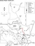
 The unmistakable profile of Cochise Head Mountain dominates the far-reaching views that form the main attraction along this crest trail. The granite-topped mountain was named for the charismatic Chiricahua Apache, Cochise, who was a leader of his people in the mid-1800s. The trail starts high on Onion Saddle, where Forest Road 42 crosses the backbone ridge of the Chiricahuas. From the northeast corner of that crossroads, it heads north and west into a remote corner of the mountain range that sees relatively few people. That was not always the case. In the past, this area was the site of considerable mining activity. At one time there was even a tunnel through one of the ridges that enabled children from the western slopes to walk to the east side school. The mines have closed and the tunnel has collapsed, but a number of old roads and ruins of abandoned diggings remain, along with some of the best views in the Chiricahuas. From Onion Saddle, Shaw Peak Trail starts out along an old road that once provided access to the Misfire Mine. Road and trail soon part company, however, and the path continues over the north summit of Onion Peak to Jhus-Horse Saddle. Here it meets two other trails, Pinery-Horsefall # 336 and Jhus-Horse Saddle #252. From this junction, the trail climbs to Shaw Saddle for more great views before dropping to the Hilltop Mine, marked by a large tailings dump. Beyond the mine, it is approximately 2.2 miles of 4-wheel drive road along the North Fork of Pinery Canyon to FR 42. The unmistakable profile of Cochise Head Mountain dominates the far-reaching views that form the main attraction along this crest trail. The granite-topped mountain was named for the charismatic Chiricahua Apache, Cochise, who was a leader of his people in the mid-1800s. The trail starts high on Onion Saddle, where Forest Road 42 crosses the backbone ridge of the Chiricahuas. From the northeast corner of that crossroads, it heads north and west into a remote corner of the mountain range that sees relatively few people. That was not always the case. In the past, this area was the site of considerable mining activity. At one time there was even a tunnel through one of the ridges that enabled children from the western slopes to walk to the east side school. The mines have closed and the tunnel has collapsed, but a number of old roads and ruins of abandoned diggings remain, along with some of the best views in the Chiricahuas. From Onion Saddle, Shaw Peak Trail starts out along an old road that once provided access to the Misfire Mine. Road and trail soon part company, however, and the path continues over the north summit of Onion Peak to Jhus-Horse Saddle. Here it meets two other trails, Pinery-Horsefall # 336 and Jhus-Horse Saddle #252. From this junction, the trail climbs to Shaw Saddle for more great views before dropping to the Hilltop Mine, marked by a large tailings dump. Beyond the mine, it is approximately 2.2 miles of 4-wheel drive road along the North Fork of Pinery Canyon to FR 42.Views as good as they get, Historic mining district, Remote area, Biological diversity. This trail can be hard to follow. Use a topographic map and a compass. USGS Map: Rustler Park Check out the Official Route and Triplog. Note This is a moderately difficult hike. Leave No Trace and +Add a Triplog after your hike to support this local community. One-Way Notice This hike is listed as One-Way. When hiking several trails on a single "hike", log it with a generic name that describes the hike. Then link the trails traveled, check out the example. | ||||||||||||||||||||||||||||||||||||||||||||||||||||||||||||||||||||||||||||||||
 Route Editor


